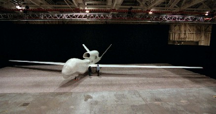
Two
employees of Teledyne Ryan Aeronautical look at the fuselage of the Global
Hawk, the Department of Defense's newest unmanned air vehicle (UAV), in
a hangar in San Diego, Calif. before its roll out on Feb. 20, 1997. Global
Hawk is a high-altitude, long-endurance unmanned aerial reconnaissance
system that will provide military field commanders with high-resolution,
near-real-time imagery of large geographic areas. The Global Hawk is optimized
for low-to-moderate threat, long endurance reconnaissance missions where
range, endurance and persistent coverage are paramount. The vehicle, with
its 116- foot wingspan and 44-foot length, carries both synthetic aperture
radar and electro-optical and infrared sensors. The Global Hawk system
will be able to survey, in one day, an area equivalent to the state of
Illinois (40,000 square nautical miles), while providing imagery with a
three-foot resolution. Alternatively, the system can provide more detailed
spot images of one-foot resolution, if needed. For a typical mission, the
Global Hawk system can fly to a target area 3,000 nautical miles away,
and stay airborne for 24 hours collecting data before returning. It flies
at altitudes up to 65,000 feet. This summer, the air vehicle will move
to the Air Force Flight Test Center, Edwards Air Force Base, Calif., where
flight tests will occur. The Global Hawk's first flight is expected in
late summer or early fall. Photo by David Gossett, courtesy of Teledyne
Ryan Aeronautical.