PREFACE
The R-2508 Complex is a tri-service test complex used by the Department of Defense for advancement and employment of weapons systems technology. Aircraft research and development in all regimes of flight from spins to supersonic cruise as well as development/operational weapons test and evaluation flights which take place daily. Additionally, student pilot training, air combat maneuvering, and proficiency flights are scheduled in the R-2508 Complex.
This handbook is published under the authority of the R-2508 Joint Policy and Planning Board (JPPB) and developed by the R-2508 Complex Control Board (CCB). It contains procedures for R-2508 Complex missions, scheduling, and aircrew briefing. Unit Commanders and authorized civilian activities using the R-2508 Complex are responsible for ensuring compliance with the provisions of this handbook.
R-2508 COMPLEX USER'S HANDBOOK
TABLE OF CONTENTS
Page
PREFACE i
RECORD OF CHANGES iii
TABLE OF CONTENTS v
LIST OF FIGURES ix
LIST OF APPENDIX x
CHAPTERS:
1 INTRODUCTION 1-1
1-1 POLICY 1-1
1-2 CANCELLATION 1-1
1-3 EFFECTIVE DATE 1-1
1-4 RECOMMENDED CHANGES 1-1
1-5 AUTOMATIC DISTRIBUTION 1-1
1-6 ABBREVIATIONS, ACRONYMS, AND TERMS 1-1
2 R-2508 COMPLEX MANAGEMENT AND CONTROL
2-1 AIRSPACE MANAGEMENT 2-1
a. R-2508 Joint Policy and Planning Board 2-1
b. R-2508 Complex Control Board 2-1
c. R-2508 Central Coordinating Facility 2-1
2-2 CONTROLLING AGENCY 2-2
2-3 USING AGENCY 2-2
3 R-2508 COMPLEX USE AND DESCRIPTION 3-1
3-1 R-2508 COMPLEX AIRSPACE DESCRIPTION 3-1
a. General 3-1
b. R-2508 Complex Shared Use Airspace 3-1
c. R-2508 Complex Special Use Airspace Vertical Boundary Definitions 3-1
d. Daggett Shelf 3-6
e. Golden Triangle 3-6
f. Released Airspace Status 3-8
3-2 TYPE OF ACTIVITY WITHIN WORK AREAS 3-8
a. Scheduled Complex Activity 3-8
Isabella Work Area 3-8
Barstow Work Area 3-8
Buckhorn Work Area 3-8
Owens Work Area 3-8
Saline Work Area 3-10
Panamint Work Area 3-10
b. Military Low Observable Platforms 3-10
c. General Aviation 3-10
d. Hang Gliders 3-10
e. Ultralight 3-10
f. Sailplane 3-10
g. California City Airport 3-12
h. Land Management Agencies 3-12
i. R-2508 Complex Entry/Exit Points 3-12
j. Bakersfield and Porterville Work Areas 3-12
3-3 SENSITIVE AREAS 3-12
a. National Parks/Wilderness Areas Altitude Restrictions 3-12
b. Populated Areas Overflight 3-14
c. Owens Valley 3-14
d. Paved Roads 3-14
e. Other Caution Areas 3-14
4 R-2508 COMPLEX OPERATING PROCEDURES 4-1
4-1 GENERAL 4-1
a. Scheduling Agencies 4-1
b. "Lights Out" Procedures 4-2
c. Electronic Counter Measures/Chaff/Flares 4-2
d. Flares 4-3
e. Tanker Areas 4-3
f. Supersonic Operations 4-6
g. Airborne Radar Unit (ARU) 4-6
h. Open Skies 4-6
i. R-2508 Situation Report 4-7
4-2 SCHEDULING PROCEDURES 4-8
a. CCF Responsibilities 4-8
b. Airspace Scheduling 4-8
c. Aircraft Scheduling 4-8
4-3 UNSCHEDULED AIRCRAFT POLICY 4-10
a. Scheduling Requirements 4-10
b. Enforced Procedures 4-10
4-4 SCHEDULING OF SPECIAL OPERATIONS 4-10
a. Special Operations Definition 4-10
b. Scheduling Request 4-11
c. Lead Time 4-11
4-5 SCHEDULING OF LARGE SCALE EXERCISES 4-11
a. Definition of Large Scale Exercise 4-11
b. Planning Requirements 4-11
c. Points of Contact 4-12
d. CCF Coordination 4-12
4-6 FLIGHT PLANNING 4-13
a. Flight Plan Filing 4-13
b. Flight Plan Procedures 4-13
4-7 FLYING PROCEDURES 4-14
a. General 4-14
b. Specific Procedures 4-15
c. Operating Procedures 4-16
4-8 UNMANNED AERIAL VEHICLE OPERATIONS 4-18
a. Scheduling Requirements 4-18
b. Work Area Clearance 4-19
5 INDIVIDUAL RANGE/RESTRICTED AREA OPERATING PROCEDURES 5-1
5-1 R-2502N AND R-2502E, NATIONAL TRAINING CENTER, FORT IRWIN 5-1
a. Area Description 5-1
b. Command and Control Facilities 5-1
c. Scheduling 5-3
d. Special Procedures 5-3
5-2 R-2505, NAVAL AIR WARFARE CENTER WEAPONS 5-4
DIVISION, CHINA LAKE
a. Area Description 5-4
b. Command and Control Facilities 5-4
c. Scheduling 5-4
d. Special Procedures 5-6
5-3 R-2506, NAVAL AIR WARFARE CENTER WEAPONS 5-6
DIVISION, CHINA LAKE
a. Area Description 5-6
b. Command and Control Facilities 5-6
c. Scheduling 5-6
d. Special Procedures 5-6
5-4 R-2524, NAVAL AIR WARFARE CENTER WEAPONS 5-6
DIVISION, CHINA LAKE
a. Area Description 5-6
b. Command and Control Facilities 5-8
c. Requests and Scheduling 5-8
d. Special Procedures 5-8
5-5 R-2524 SUPERIOR VALLEY TACTICAL TRAINING RANGE, 5-8
NAVAL AIR WARFARE CENTER WEAPONS DIVISION, CHINA LAKE
a. Area Description 5-8
b. Command and Control Facilities 5-10
c. Requests and Scheduling 5-10
d. Special Procedures 5-10
5-6 R-2515, AIR FORCE FLIGHT TEST CENTER, 5-11
EDWARDS AFB
a. Area Description 5-11
b. Command and Control Facilities 5-11
c. Scheduling 5-11
d. Special Procedures 5-13
LIST OF FIGURES
FIGURES Page
3-1 R-2508 COMPLEX VERTICAL DIMENSIONS 3-2
3-2 R-2508 COMPLEX RESTRICTED AREA VERTICAL DIMENSIONS 3-3
3-3 R-2508 COMPLEX MOAs VERTICAL DIMENSIONS 3-4
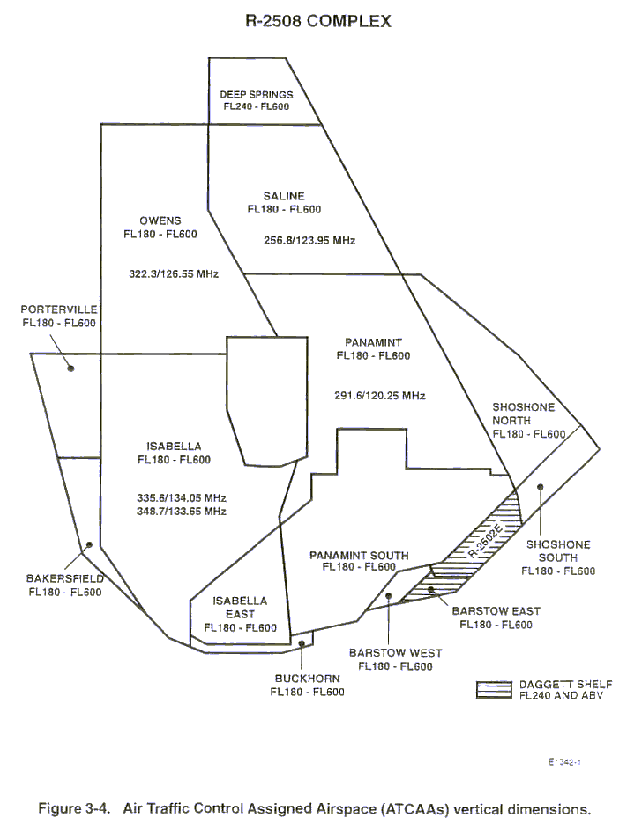
3-4 R-2508 COMPLEX ATCAAs VERTICAL DIMENSIONS 3-5
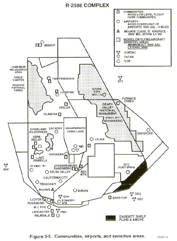
3-5 R-2508 COMPLEX COMMUNITIES, AIRPORTS, NOISE/LOW FLYING 3-7
AIRCRAFT SENSITIVE AREAS
3-6 R-2508 COMPLEX MILITARY TRAINING ROUTES 3-9
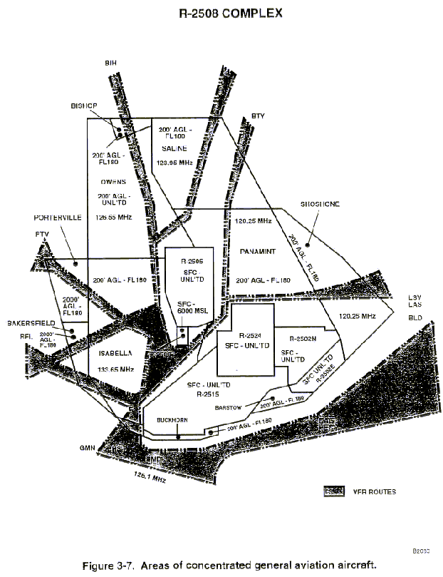
3-7 R-2508 COMPLEX AREAS OF CONCENTRATED GENERAL AVIATION 3-11
AIRCRAFT
3-8 R-2508 COMPLEX ENTRY/EXIT POINTS 3-13
4-1 R-2508 COMPLEX TRANSIT ROUTES, REFUELING AREAS, 4-4
AND MANEUVERING AREAS
4-2 SAMPLE DD-175 4-13
5-1 R-2502N AND R-2502E 5-2
5-2 R-2505 5-5
5-3 R-2524 5-7
5-4 R-2524 BYPASSES 5-9
5-5 R-2515 5-12
LIST OF APPENDIX
A - MILITARY AIRBORNE RADAR UNIT AND AIRBORNE WARNING A-1
AND CONTROL SYSTEMS OPERATIONS
B - LARGE SCALE EXERCISE PLANNING CHECKLIST B-1
C - STANDARDIZED INPUT FORMAT (Quick Reference) C-1
D - MOA/ATCAA DEFINITIONS BY LATITUDE/LONGITUDE D-1
E - UAV GUIDELINES E-1
F - R-2508 COMPLEX SITUATION REPORT F-1
G - TOWED OBJECTS WITHIN THE R-2508 COMPLEX AIRSPACE G-1
1-1. POLICY. This handbook prescribes policy and standard operating procedures for aircrews operating in the R-2508 Complex.
1-2. CANCELLATION. R-2508 COMPLEX USER'S HANDBOOK dated 1 January 1995 is canceled.
1-3. EFFECTIVE DATE. This book is effective 1 May 1997.
1-4. RECOMMENDED CHANGES. Recommended changes should be forwarded to:
R-2508 Central Coordinating Facility
412 OSS/OSAC
100 E. Sparks Dr.
Edwards AFB,CA 93524-8090
Message
2508CCF EDWARDS AFB CA//
Telephone
DSN 527-2508, (661) 277-2508
Telefax
DSN 527-4798, (661) 277-4798
1-5. AUTOMATIC DISTRIBUTION. To receive future changes or revisions to this handbook, units should forward requests to the R-2508 Central Coordinating Facility (CCF), see paragraph 1-4.
1-6. ABBREVIATIONS, ACRONYMS, AND TERMS. As used in this handbook, the following items have the meanings indicated:
ITEM MEANING
AAF Army Air Field
ACM Air Combat Maneuvering
AFB Air Force Base
AFFS Army Flight Following Service
AFFTC Air Force Flight Test Center
AGGR Air to Ground Gunnery Range
AGL Above Ground Level
ALTRV Altitude Reservation
ARTCC Air Route Traffic Control Center
ARU Airborne Radar Unit
ASC Airspace Surveillance Center
ATC Air Traffic Control
ATCAA Air Traffic Control Assigned Airspace
ATO Air Tasking Order
AWACS Airborne Warning and Control System
BFM Basic Fighter Maneuvers
CAS Close-Air Support
CCB Complex Control Board
CCF R-2508 Central Coordinating Facility
DOD Department of Defense
DME Distance Measuring Equipment
DSN Defense Switching Network
ECM Electronic Counter Measures
ECR Electronic Combat Range
EW Electronic Warfare
FAA Federal Aviation Administration
FAR Federal Air Regulation
FL Flight Level
FLIP Flight Information Publication
GCI Ground Control Intercept
GP General Planning
IFR Instrument Flight Rules
JPPB Joint Policy and Planning Board
LOA Letter of Agreement
MOA Military Operations Area
MRU Military Radar Unit
MSL Mean Sea Level
MTR Military Training Route
NACC NTC Airspace Control Center
NAS Naval Air Station
NAWCWPNS Naval Air Warfare Center Weapons Division
NAWS Naval Air Weapons Station
NM Nautical Miles
NOTAM Notice to Airman
NTC National Training Center
NVD Night Vision Devices
OT&E Operational Test and Evaluation
POC Point of Contact
PPR Prior Permission Required
RCO Range Control Officer
RCF Radar Control Facility
RDT&E Research, Development, Test, and Evaluation
RTB Return to Base
SFC Surface
SUA Special Use Airspace
TFR Temporary Flight Restriction
TRACON Terminal Radar Approach Control
TW Test Wing
TS Test Squadron
UAV Unmanned Aerial Vehicle
VFR Visual Flight Rules
2-1. AIRSPACE MANAGEMENT.
Management of the R-2508 Complex is the responsibility of the R-2508 Joint Policy and Planning Board (JPPB), founded in 1975 at the direction of the Joint Logistics Commanders and approved by the respective Service Chiefs and the Office of the Secretary of Defense. JPPB members are the Commanders of the NAWCWPNS, China Lake; AFFTC, Edwards AFB; and NTC, Fort Irwin. The JPPB establishes broad operational policy and is the approving authority of all matters dealing with the joint management/control of military activities within the Complex. The mission of the JPPB is the enhancement and preservation of the R-2508 Complex bases, ranges, and special use airspace; and to increase the Department of Defense (DOD) capability for Research, Development,Test, and Evaluation (RDT&E) of aircraft and weapons systems. Additionally, the JPPB preserves an area for operational training and readiness of DOD sponsored activities.
The R-2508 Complex Control Board (CCB), established in 1955, is comprised of representatives from each command. The CCB conducts the R-2508 Complex management function. The CCF, under direction of the CCB, is the designated scheduling authority for R-2508 Complex shared-use airspace. The mission of the CCB is to supervise the management of the R-2508 Complex. TheCCB assists the JPPB Commanders by formulation of advice and assistance in the conduct of JPPB matters and by relieving them of details in the conduct of day-to-day business such as developing procedures for shared use airspace, resolution ofprocedural conflicts, and real-time decision making.
Within the policy, scope, and limitations imposed by the CCB, the CCF has autonomous authority pertaining to R-2508 Complexshared use airspace utilization when the Complex is scheduled/activated for military use. The CCF exercises this authority in matters relating to airspace use and management of the R-2508 Complex; specifically:
(1) To manage, document, and coordinate on a scheduled and real-time basis the airspace utilization and mission requirements of all military and civil users of the R-2508 Complex.
(2) Act as the single point for coordination of R-2508 Complex activities with High Desert TRACON and missioncontrol facilities.
(3) Release and recall of R-2508 Complex airspace.
(4) Administrative support of R-2508 Complex administrative requirements, facilities, equipment, projects, and Operations and Maintenance (O&M) budget.
2-2. CONTROLLING AGENCY. High Desert Terminal Radar Approach Control (TRACON), a FAA Air Traffic Control Facility, is the controlling agency for the R-2508 Complex. TRACON's call sign is "JOSHUA APPROACH."
2-3. USING AGENCY. Internal Restricted Areas. Internal restricted areas within the R-2508 Complex (R-2502N, R-2502E, R-2505, R-2506, R-2515, and R-2524) are scheduled and controlled by their respective "designated Using Agencies." See Chapter 4 for scheduling and operating procedures for internal restricted areas.
3-1. R-2508 COMPLEX AIRSPACE DESCRIPTION.
a. General. The R-2508 Complex includes all the airspace and associated land presently "owned" and managed by the three principal military activities in the Upper Mojave Desert region: Air Force Flight Test Center (AFFTC), Edwards Air Force Base (AFB); National Training Center (NTC), Fort Irwin, and Naval Air Warfare Center Weapons Division (NAWCWPNS), China Lake. The R-2508 Complex is composed of a number of restricted areas, Military Operations Areas (MOA), and Air Traffic Control Assigned Airspace (ATCAA) areas as defined in the following paragraphs.
b. R-2508 Complex Shared Use Airspace. The Military Operations Areas (MOA) and Air Traffic Control Assigned Airspace (ATCAA) areas are combined with R-2508 to form the four major work areas; Isabella, Owens, Saline, and Panamint. This creates working airspace from near the surface upwards throughout the entire R-2508 Complex. Isabella, Saline, and Panamint work areas have peripheral areas made up of MOA and/or ATCAA airspace to increase the size of the usable airspace (Figure 3-1).
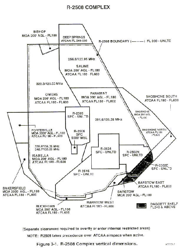
c. R-2508 Complex Special Use Airspace Vertical Boundaries. Descriptions of the lower and upper altitude boundaries for the various types of special use airspaces (Figures 3-1, 3-2, 3-3, and 3-4) are as follows:
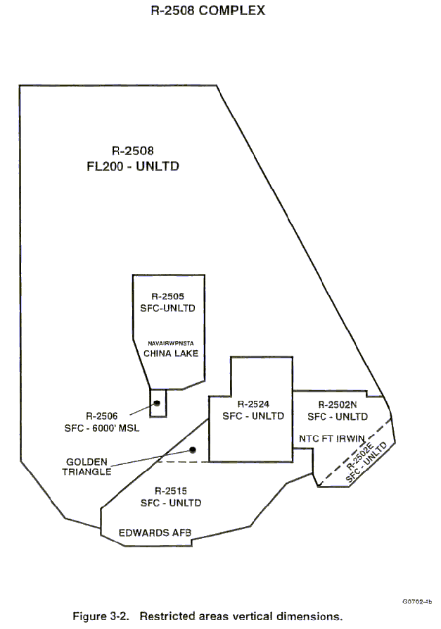
(1) Restricted Areas. Restricted Area R-2508, the major restricted area from which the R-2508 Complex derives its name, extends from FL200 upward to unlimited and is shared use airspace. Individual restricted areas, R-2502N, R-2502E, R-2505, R-2506, R-2515, and R-2524 require prior approval for entry. These internal restricted areas have vertical dimensions of surface to unlimited, except, R-2506, which extends from surface to 6000' MSL (Figure 3-2).
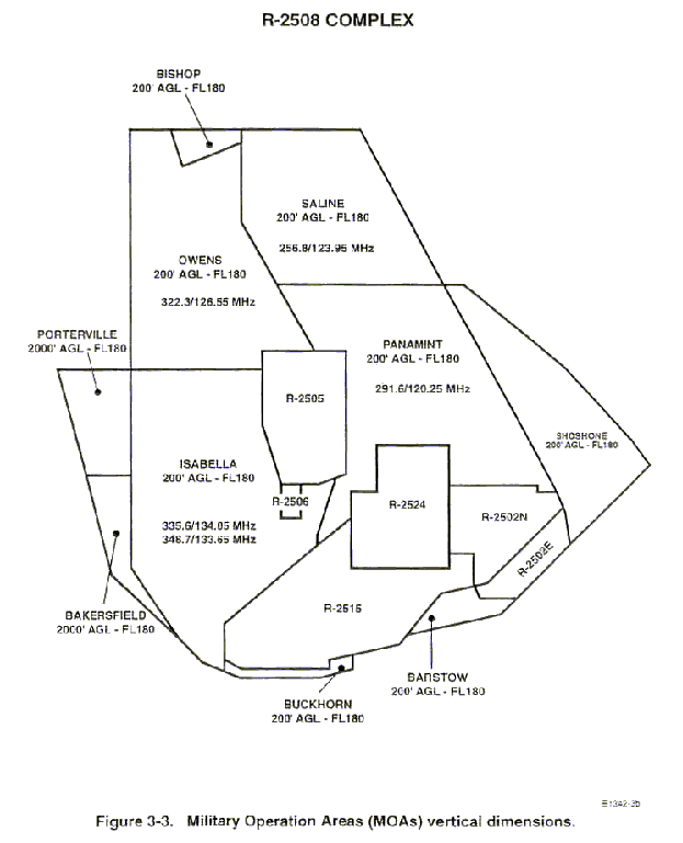
(2) Military Operations Areas. The four main MOA work areas, Isabella,
Owens, Saline, and Panamint, along with Barstow, Buckhorn, Bishop, and
Shoshone MOAs, have a minimum altitude boundary of 200' AGL; and Bakersfield
and Porterville MOAs have a minimum altitude of 2000' AGL (Figure 3-3 and
Appendix D). Portions of the four major work areas are located over Sequoia/Kings
Canyon National Parks, John Muir and Domeland Wilderness Areas, and Death
Valley National Park (See "NOTE" below) where the lower limit of the MOA
is 3,000' AGL. MOAs do not include the airspace below 1,500' AGL within
three miles of any charted airport; except, Mojave Airport Class D airspace.
NOTE
Exclusion of MOA airspace above the Death Valley National Park and Domeland
Wilderness Area applies to the 1977 contours of the former National Monument and Wilderness Area. This difference in affected airspace may not be accurately reflected in Sectional Charts. Refer to Figure 3-5 and contact CCF if further information is required.
(3) Air Traffic Control Assigned Airspace. The ATCAAs (Figure 3-4 and Appendix D) are used to fill the airspace gap between the top of the MOAs (FL180) and the base of R-2508 (FL200). When R-2508 is not activated, the ATCAAs may extend upward to FL600. ATCAAs are also located above the peripheral MOAs, which are outside the lateral boundaries of R-2508, to afford additional areas up to FL600 for segregation of military operations from IFR traffic. Deep Springs is formed solely of ATCAA airspace from FL240 to FL600. Isabella East and Panamint South ATCAAs, FL180 to FL600, are set up within the boundaries of R-2515, R-2502N, R-2502E, and R-2524 to be used as an air traffic control aid for military operations when the restricted areas have been declared "cold."
CAUTION
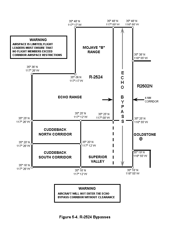
d. Daggett Shelf. The Daggett Shelf consists of Barstow East ATCAA, R-2502 East, and that portion of R-2508 which coincides with R-2502E, FL240 and above (Figure 3-1). The Daggett Shelf was established by LOA to provide FAA relief for control of IFR traffic through the DAGGETT/HECTOR corridor. The Daggett Shelf along with Shoshone South ATCAA airspace remains under ARTCC control until TRACON requests and receives control of the airspace. Aircrews scheduled for or requiring one or more of the areas that comprise the Daggett Shelf or Shoshone South ATCAA FL240 or above shall request the area(s) and altitudes from TRACON. Aircrews should expect up to 10 minutes delay for transfer of control of the airspace from Center to TRACON. Aircrews SHALL NOT enter any portion of the Daggett Shelf or Shoshone South until specific notification or clearance has been received from TRACON.
e. R-2515 GOLDEN TRIANGLE.
(1) Definition. That portion of R-2515 which extends north of the westerly extension of R-2524's southern boundary. See Figure 3-2.
(2) Coordinates: Beginning at 35°27¢40²N/117°26¢03²W
thence direct 35°15¢56²N/117°26¢03²W
thence direct 35°15¢56²N/117°43¢41²W
thence to point of beginning
(3) Scheduling. The R-2508 Central Coordinating Facility has been delegated scheduling authority for the Golden Triangle by Edwards AFB. Units requiring this area for transition in/out of R-2524 will schedule the requirement with CCF. CCF will enter GT on the mission's schedule with it appearing on the FAA Flight Progress strip as "GT."
(4) Scheduling/Strip Marking Identifier: GT
(5) Operational Procedures. ASC shall coordinate a radar "Point Out" of aircraft under their control to SPORT or TRACON, if the airspace has been released to TRACON control, prior to entering the Golden Triangle.
f. Released Airspace Status. The internal restricted areas are "owned" by individual military agencies which may be released for joint DOD use. When this occurs, the released airspace becomes part of the basic R-2508 Complex.
3-2. TYPE OF ACTIVITY WITHIN WORK AREAS.
a. Scheduled Complex Activity. Aircraft research and development in all stages of flight from spins to supersonic cruise; operational weapons test and evaluation flights; student training; air combat maneuvering and proficiency flights; and civilian test aircraft in direct support of DOD and/or commercial defense testing are typical operations in the R-2508 Complex, which may support in excess of 350 aircraft sorties on any normal day. Test operations must remain flexible and airspace requirements are not entirely predictable. Therefore, to best use the available airspace, participating aircraft operating in R-2508 Complex shared use airspace are not segregated. Participating aircraft must accept radar traffic advisories and use the "SEE and AVOID" principle to avoid interfering with the missions of other aircraft.
(1) Isabella is heavily used by Edwards AFB, at all altitudes, with rapid maneuvering and ACM conducted over Saltdale/Koehn Lake (35°20¢N/117°53¢W). Most arrivals and departures from China Lake transit Isabella. Refueling aircraft frequently orbit in Isabella in support of restricted area operations. Additionally, Isabella is a primary holding point for armed aircraft utilizing R-2505 and test aircraft utilizing R-2524. Several Military Training Routes (MTRs) also transit the area (Figure 3-6).
(2) Barstow is used by helicopter and Air Warrior aircraft entering/exiting R-2502N and R-2502E or holding awaiting entering of R-2502N and R-2502E, military traffic on VR1217/VR1218, and Edwards AFB flight test operations. (Figure 3-6).
(3) Buckhorn is used extensively to support Edwards AFB test missions. (Figure 3-1).
(4) Owens is used primarily by Edwards AFB, China Lake, Fresno ANG, and NAS Lemoore for Operational Test and Evaluation (OT&E), Air Combat Maneuvering (ACM), and training flights. Several MTRs also transit Owens. (Figure 3-6).
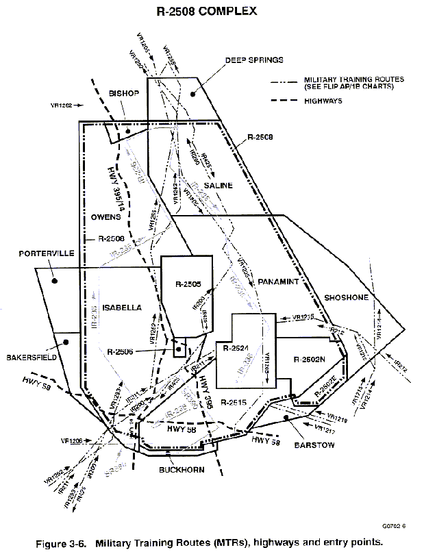
(5) Saline is used by aircraft from Edwards AFB, China Lake, Fresno ANG, Nellis AFB, and NAS Lemoore for Test and Evaluation, Air Combat Maneuvering (ACM), and training flights. Saline Valley is used for low altitude refueling activities. Several MTRs also transit Saline. (Figure 3-6).
(6) Panamint is used routinely in support of R-2502N, R-2502E, and R-2524 operations and by Nellis AFB and China Lake units; Fresno ANG and Edwards AFB. Panamint and Shoshone are primarily used for OT&E, ACM, low altitude training, and large scale exercises. Several MTRs transit these areas (Figure 3-6). Shoshone is also used for low altitude tanking operations in support of large scale exercises.
b. Military Low Observable Platforms.
(1) Low observable platforms (i.e., F-117A, B-2A) conduct flight tests throughout the R-2508 Complex. During these missions it is critical these aircraft not be used as targets of opportunity for any ground, airborne, or space based sensors or emitters. If these aircraft are inadvertently tracked by any device, the resulting data is classified and must be afforded proper safeguards. After flight, the incident must be immediately reported to the 412 TG/TSR, DSN 525-8043, or 420 TS/DO, DSN 525-8035 for disposition of data and debriefing instructions.
(2) The discussion of information relating to sensor effectiveness in acquiring, tracking, and targeting these aircraft with anyone other than the person assigned to investigate the incident is not permitted. Failure to comply with this direction may be in violation of Federal and DOD regulations and policy for the protection of classified information as they relate to Special Access Required (SAR) programs.
c. General Aviation. General aviation aircraft fly unrestricted in accordance with Visual Flight Rules (VFR) within the R-2508 Complex MOAs below FL180. Figure 3-7 depicts the most heavily flown routes.
d. Hang glider operations are conducted along the Sierra Nevada Mountain Range and along the northeast shoreline of Owens Dry Lake through the Owens Valley along the Inyo Mountain Range to Bishop, California.
e. Ultralight activity is also popular in many areas throughout the R-2508 Complex MOAs. This activity is primarily concentrated around towns and civil airports within the R-2508 Complex.
f. Sailplane activities are conducted daily from the Tehachapi Mountain
Valley, Lone Pine, Independence, Rosamond, Mojave, California City, and
Inyokern airports.
A sailplane Wave Camp, is charted in the Isabella MOA and can be scheduled for use whenever soaring conditions permit. Sailplane operations can be extremely heavy in the area of California City Airport due to launch/recovery and flights transitioning between the airport and the Wave Camp area. The heaviest concentration of sailplane operations is expected along and East of the Sierra Nevada mountain range from Tehachapi Pass to the
mouth of Lone Tree Canyon, 13 NM Northeast of Tehachapi Pass. Sailplane operations below FL180 are not confined to Isabella MOA, but remain clear of restricted areas. Sailplane operations FL180-FL500 are restricted to the Wave Camp area bounded by California City Airport, Mojave Airport, Highway 58/Tehachapi Pass, and mouth of Lone Tree Canyon. Coordinates for this area are:
Beginning at 35°09¢N/118°01¢W (California City Airport)
thence direct 35°03¢N/118°09¢W (Mojave Airport)
thence direct 35°06¢N/118°18¢W (Highway 58/Tehachapi Pass)
thence direct 35°14¢N/118°05¢W (mouth of Lone Tree Canyon)
thence direct to point of beginning.
g. California City Airport is used for parachute activities from surface to 17,500 feet MSL by private parachute clubs and occasionally by military aircraft.
h. Unmanned Aerial Vehicles (UAVs) operate in the R-2508 Complex typically at altitudes above 40,000 feet MSL. UAVs have been launched into the Complex from Edwards AFB, China Lake, and El Mirage, but operations are not limited to these areas.
i. Unmanned Rocket launches occur within the Complex from locations approximately eight miles west of Randsburg, Calif. (PMD004/45 or 35° 21'N/117°48'W, and PMD 358/43 or 35° 20'N/117° 52'W). Rockets must stay within a radius of statute miles from the launch site. Operations are limited to daylight hours only and are not permitted when surface visibility in the launch area is less than three miles and/or into clouds. The maximum rocket altitude allowable, when the R-2508 Complex is activated for military use, is 18,000feet MSL.
j. Land Management Agency helicopters and fixed wing aircraft operate, in the R-2508 Complex, primarily in the western portions of Isabella and Owens. Administrative support aircraft operations are normally 1,500' AGL and below. Actual fire fighting and related support operations will normally be conducted within a Temporary Flight Restriction (FAR 91.137) NOTAM area within a defined area and altitude block. However, aircraft operations to/from staging bases may occur outside of the NOTAMed fire areas.
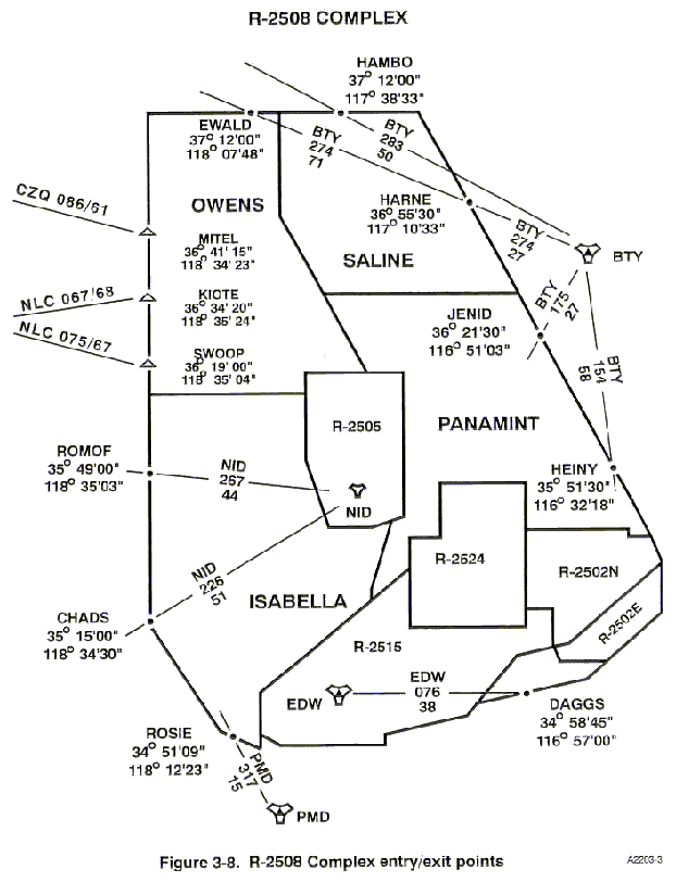
k. R-2508 Complex entry/exit points for VFR and IFR military activities are depicted on Figure 3-8.
l. Bakersfield and Porterville MOAs/ATCAAs, Deep Springs ATCAA, and Bishop MOA must be scheduled in advance with CCF to ensure accomplishment of required pre-coordination with Los Angeles or Oakland ARTCC.
3-3. SENSITIVE AREAS. The military mission within the R-2508 Complex has long enjoyed the support of the population that lives beneath the R-2508 Complex airspace. This support is essential to DOD's effort to preserve the R-2508 Complex for future military use. Occasional damage from sonic booms and frequent noise complaints relating to low level flight over small towns, airports, and recreation areas have done serious damage to the DOD/civilian community relationship. Aircrews must adhere to Federal Air Regulations (FAR) and DOD rules pertaining to supersonic operations, endangering private property and annoyance to civilians. Areas of concern are as follows:
a. National Parks/Wilderness Areas Altitude Restrictions
(1) A minimum altitude of 3000 feet AGL and lateral distance of 3000 feet (approximately 1/2 nautical mile) shall be maintained over and from the Death Valley National
Monument, Sequoia and Kings Canyon National Parks, and the Domeland and John Muir Wilderness Areas as depicted in Figure 3-5. Due to the high visibility and potential impact on DOD, land management agencies and civilian populace relations; aircrews are encouraged to avoid these areas to the maximum extent possible. Missions requiring overflight of these areas should take extra precaution to abide by the overflight altitudes. Exclusion of MOA airspace above Death Valley National Park and Domeland Wilderness Area applies to the 1977 contours of the former National Monument and Wilderness Area. This difference in affected airspace may not be accurately reflected in sectionals. Refer to Figure 3-5, and contact CCF with any further questions.
(2) Low flying aircraft over National Parks and Wilderness Areas is an extremely sensitive issue. Strict vigilance is required.
b. Populated Areas Overflight. Aircrews should avoid overflight below 3000 feet AGL over inhabited areas and communities; including, Keeler, Lone Pine, Trona, Inyokern, Independence, Olancha, Tehachapi, Randsburg, Johannesburg, Red Mountain and Ridgecrest Lake Isabella, and Kernville. Recreational use near these communities and along the Kern River is high in the summer months. Aircrews should anticipate increased sensitivity to operations near these areas. Avoid low level overflight of any obviously inhabited area. See Figure 3-5 for a depiction of sensitive areas.
c. Owens Valley. Aircrews should avoid conducting ACM activities over towns, especially in the Owens Valley. Though the ACM activity may be at legal altitudes the concentration of noise over the valley floor creates a noise nuisance for the civilian populace in the area. The towns of Lone Pine and Independence have become very sensitive to the noise created by military activities in their area, and flight activities should avoid these areas to the maximum extent possible.
d. Paved Roads. Aircrews should avoid low altitude flight directly over paved roads.
e. Other Areas of Concern:
(1) The official duck hunting season runs between October and January during the birds' southern migration. Little Lake is one of the migratory stops and is also home to a private hunting club which organizes commercial hunting activity at that site (35°57¢N/117°54¢W). Aircrews should be alert for dangers of bird strikes transiting low-level through this area during hunting season.
(2) Extra caution should be used between the months of October through March within plus or minus one hour of sunrise and sunset for increased bird activity within all the MOA's.
(3) A gold mining operation at a Randsburg mine (35°56¢17²N/117°11¢09²W), conducts blasting with a vertical hazard footprint up to 400' AGL. Blasting is scheduled daily between 1400 (L) - 1700 (L).
(4) A gold mining operation located in the Panamint Valley, approximately
7 miles south of Ballarat (36°56¢17²N/117°11¢09²W),
conducts daily blasting between 1130 (L) - 1300 (L). Flyrock hazard to
indeterminable altitudes; direct overflight should be avoided during blasting
periods.
4-1. GENERAL.
a. Scheduling Agencies. Unlike most special use airspace, the R-2508 Complex is a tri-service operation with several controlling/scheduling agencies. The scheduling process may require users to coordinate and schedule planned activities with more than one agency. Therefore, units planning operations in R-2508 Complex airspace should be prepared to coordinate and schedule through the agency(ies) having scheduling and operational control of the required areas as listed below. Detailed scheduling and operational procedures are contained in this chapter and in Chapter 4.
HOURS OF
AREA AGENCY OPERATIONFUNCTION TELEPHONE
R-2508/ R-2508 Central 0600-1800 M-F Scheduling DSN 527-2508
MOAs/ Coordinating (661) 277-2508
ATCAAs Facility (CCF) FAX DSN 527-4798
(661) 277-4798
Pager 800-805-2851
E-Mail: 2508CCF@edwards.af.mil
R-2502N/ NTC Fort Irwin 24 Hours Scheduling DSN 470-4320/6816
R-2502E (760) 380-4320/6816
FAX DSN 470-5500
(760) 380-5500
0800-1600 M-F Installation Aviation DSN 470-4072
Officer (760) 380-4072
FAX DSN 470-5500/5584
(760) 380-5500/5584
R-2505/ NAWCWPNS 0700-1700 M-Th Scheduling DSN 437-6800
R-2506 China Lake 0700-1600 non- (760) 939-6800
civilian payday FAX DSN 437-6950
Fridays (760) 939-6950
0700-1700 M-Th Test Management DSN 437-6807
0700-1600 non- Office (760) 939-6807
civilian payday FAX DSN 437-6950
Fridays (760) 939-6950
0700-1700 M-Th Airspace Surveillance DSN 437-6908/9
0700-1600 non- Center (ASC) (760) 939-6908/9
civilian payday FAX DSN 437-6927
Fridays (760) 939-6927
R-2515 Edwards AFB 0600-1700 M-F Scheduling DSN 527-3940
(661) 277-3940
FAX DSN 527-9785
(661) 277-9785
0700-1530 M-F Airspace Manager DSN 527-2446
(661) 277-2446
FAX DSN 527-4462/5544
(661) 277-4462/5544
R-2524 NAWCWPNS 0630-1630 M-Th ECR Scheduling DSN 437-9128
China Lake (760) 939-9128
FAX DSN 437-9152
(760) 939-9152
0630-1630 M-Th Test Management DSN 437-9149
Office (760) 939-9149
NOTE: Hours of operation may be changed due to personnel shortages or other factors. Notification of changes will be distributed by NOTAM or DOD message.
b. "Lights Out" Operations. "Lights Out" (Night Vision Device, NVD) operations must be contained within the internal restricted areas. R-2505, R-2524, R-2502N, and R-2502E scheduling agencies can authorize "lights out" operations within their designated areas. Units requiring "lights out" operations shall contact the designated internal restricted area scheduling agency, as listed in paragraph 4-1.a., to schedule "lights out" operations. Aircraft position lights shall remain on while transiting to and from the scheduled restricted area but may be turned off when authorized within the internal restricted area (excludes R-2508). Aircrews shall advise the controlling agency when commencing/terminating "lights out" operations. "Lights out" operations pertains only to the internal restricted areas and is not authorized in any other special use airspace. A waiver to FAR 91.209 is unnecessary if the aircraft is operating in a restricted area in compliance with the Using/Scheduling Agency's rules of operation for the internal restricted area.
c. Electronic Counter Measures/Chaff.
(1) Electronic Counter Measures.
Electronic Counter Measures. Electronic Counter Measures (ECM) (JAMMING and/or CHAFF) activities in the R-2508 Complex must be pre-coordinated and approved by the Western Area Frequency Coordinator (WAFC) office, DSN 351-7983 or Commercial (661) 488-1249, or the appropriate Base Spectrum Manager or Air Force Flight Test Center Spectrum Manager, DSN 527-2390 or Commercial (661) 277-2390. These activities must also be identified to the CCF during the scheduling process.
(2) Procedures.
(a) ECM/Chaff. Contact the appropriate Base Spectrum Manager or Air Force Flight Test Center Spectrum Manager [see paragraph 4-1 c. (4)], or the WAFC office and submit unit request to conduct a specific type of ECM/Chaff activity. Request(s) must include: date/time frame/altitude, type aircraft, type ECM/Chaff, and clearance number if known.
(b) The Base Spectrum Manager will coordinate mission requirements with the Western Area Frequency Coordinator (WAFC) at Point Mugu. This will be scheduled by using the airspace name followed by a number designating the type of activity requested (i.e., 1 for Chaff and 2 for ECM).
EXAMPLE: SALINE-1, 21 July, 0800-1000. (Drop specific type of Chaff in Saline MOA from 0800-1000, on 21 July)
(3) Approval. Provided the requested activity is covered by an existing clearance and scheduled with WAFC, the activity is automatically approved. If a conflict is detected, WAFC will notify the coordinating Spectrum Manager of the conflict. Spectrum Manager will notify the requesting unit and take action to resolve the conflict.
(4) Points-of-Contact. Base Spectrum Managers for R-2508 Complex and WAFC agencies are as follows:
(a) Air Force Flight Test Center, Edwards AFB - DSN 527-2390, Commercial (661) 277-2390.
(b) NAWCWPNS, China Lake - DSN 437-6827, Commercial (760) 939-6827.
(c) National Training Center, Fort Irwin - DSN 470-3280, Commercial (760) 380-3280.
(d) Western Area Frequency Coordinator - DSN 351-7983, Commercial (661) 989-7983.
d. Flares. Use of flares in the R-2508 Complex is limited to internal restricted areas (R-2502N, R-2502E, R-2505, R-2515, and R-2524) and is not authorized in R-2508, MOA, or ATCAA airspace. Flare use must be coordinated with the cognizant scheduling agency.
e. Tanker Areas.
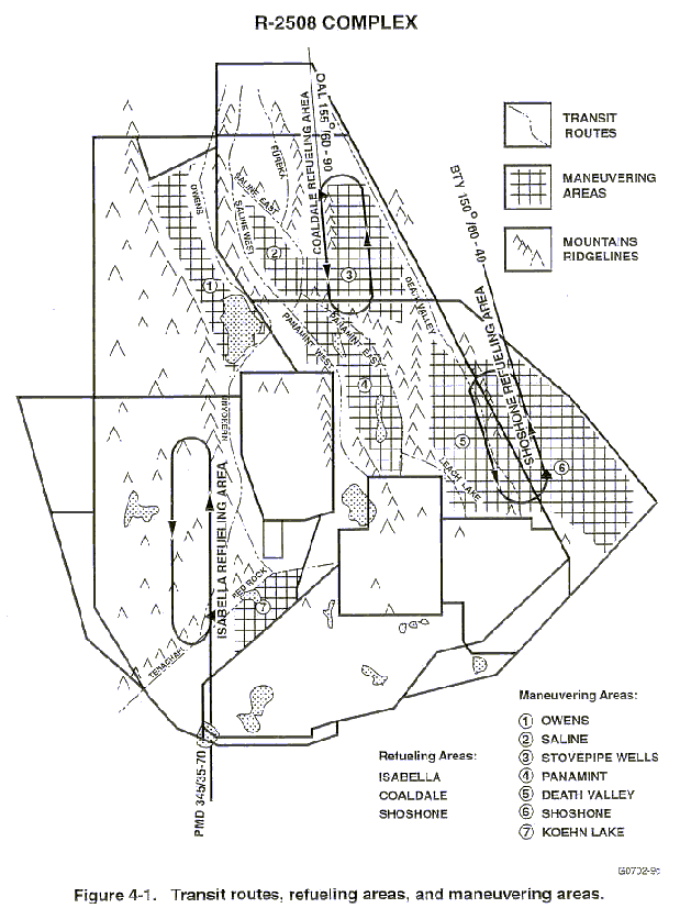
(1) There are three unpublished tanker areas established within the R-2508 Complex (Figure 4-1.) These areas are available for use and must be scheduled with the R-2508 Central Coordinating Facility (CCF). Tanker crews and receiver aircraft pilots are reminded,
these tanker areas are not exclusive use airspace and are not protected from other Complex aircraft operating in the area. The "See and Avoid" principle applies throughout your tanking operations.
(2) Tanker area definitions are as follows:
AREA NAVAID RAD/DIST LAT/LONG
(a) Isabella PMD 345/35 35°13¢N/118°04¢30²W
(b) Coaldale OAL 155/60 37°00¢N/117°33¢W
NOTE: DO NOT GO EAST OF OAL 143R.
(c) Shoshone BTY 150/60 35°50¢¢N/116°26¢W
(3) Refueling Area Directions of Flight:
(a) Isabella - Outbound on the PMD 345R, left turns.
(b) Coaldale - Outbound on the OAL 155R, left turns.
(c) Shoshone - Inbound on the BTY 150R, left turns.
(4) Refueling Areas Frequencies. Each of the R-2508 Complex refueling areas has an assigned frequency to be used during refueling operations. The assigned frequency should be used to the extent possible; if impracticable, coordinate mission/tactical frequency to be used with CCF and/or TRACON. CCF personnel will advise units/squadrons of the appropriate frequency during the scheduling/coordination process. The assigned frequencies are as follows:
AREA FREQUENCY
(a) Isabella 234.825 MHz
(b) Coaldale 252.175 MHz
(c) Shoshone 272.175 MHz
NOTE: No radar coverage available below 10,000 FT MSL for Shoshone and Coaldale refueling areas.
(5) Pilots operating in the vicinity of R-2508 Complex Tanking Areas (Isabella, Coaldale, and Shoshone), should be extra vigilant for tanking aircraft formations. If a tanker
formation is observed request pilots avoid the formation by a minimum of 2,000 feet vertically and five miles horizontally. This separation is necessary to preclude the risk of an emergency breakaway/maneuvering on the part of the tanker formation. To ascertain if a tanker area is "active" contact High Desert TRACON (Joshua Approach) and request status.
f. Supersonic Operations. Supersonic flight is not authorized in R-2508, MOAs, or ATCAAs. Supersonic operations may be conducted in internal restricted areas after specific approval from the appropriate scheduling agency. Supersonic flight may be authorized in the R-2515 High Altitude and Black Mountain Supersonic Corridors (Figure 5-5). Supersonic corridors shall be scheduled and approved by the Edwards AFB Center scheduling office, DSN 527-3940. While real-time airborne coordination may be accomplished during the normal work week, the supersonic corridors will not be available on weekends unless pre-scheduled with the designated scheduling agency prior to close of business on the Friday before intended use. All supersonic flights must be reported as directed by appropriate military service directives (OPNAVINST 3710.7, AFI 13-201).
g. Airborne Radar Unit (ARU) and Airborne Warning and Control System (AWACS) Operations. See Appendix A.
h. Open Skies.
(1) The Open Skies Treaty was ratified by the United States Senate in 1994. Under the terms of this treaty, signatory countries are authorized to operate aircraft over all national territories of the visited country (i.e., United States) under the conditions outlined in the treaty. These conditions permit access to all United States airspace without restriction. Although the treaty has not yet entered into force, the On-Site Inspection Agency (OSIA) is conducting "mock" or training flights under the terms of the treaty. Additionally, the State Department has authorized foreign overflights to be conducted in U.S. airspace in preparation for treaty implementation. These foreign overflights may be conducted from either the U.S. Open Skies platform (OC-135) or the visiting country's aircraft. In all of these pre-treaty flights, all conditions of the Open Skies Treaty, related to access to airspace and notification procedures are being exercised as they would when applied to a treaty authorized Open Skies Aircraft. Treaty provisions state that Open Skies flights take precedence over regular air traffic and allow flights through all Special Use Airspace.
(2) CCF is responsible for notification of proposed Open Skies flights to R-2508 Complex users/agencies. Notifications are to allow users/agencies to take appropriate action in preparation for the proposed flight. Upon receipt of notification of a proposed Open Skies flight, CCF will advise users/agencies of the flights details through a series of messages listed below. Request all users/agencies receiving these messages be prepared to review and modify their flight requirements for R-2508 Complex airspace based on the proposed overflight window. Notice of the actual airspaces and times affected by the Open Skies flight plan will be identified in the messages as details are available.
(a) General Alert. Advises of receipt of notification of the intent of an Open Skies flight to be conducted. Message will be received by the OSIA a minimum of 72 hours prior to the Open Skies flight aircraft arrival at the Point-of Entry (POE).
(b) Initial Alert. The Open Skies initial flight plan has been submitted for approval. This flight plan is submitted a minimum of 24 hours* before the flight departs the POE or if designated, Open Skies airfield (OSA). "*" These timelines are based on notification criteria between the affected parties (OSIA and Open Skies participants) and will likely be decreased by delays for completion of notification process to CCF and transmittal of the information to Complex users.
(c) Final Flight Plan. Approved flight plan for the Open Skies flight, normally received at least 16 hours* before the flight. Message will list R-2508 Complex airspace that will be affected by the Open Skies flight by direct overflight and/or sensor coverage. ). "*" These timelines are based on notification criteria between the affected parties (OSIA and Open Skies participants) and will likely be decreased by delays for completion of notification process to CCF and transmittal of the information to Complex users.
(d) Stand Down. Confirms Open Skies flight will not impact R-2508 Complex Airspace. Message would be received instead of the final flight plan message, if appropriate.
(e) Flight Plan Update. Sent when time permits and provides updated flight plan and/ or times. Message will not be received if the Open Skies aircraft flight path or expected time of arrival at R-2508 Complex boundary has not changed or a "Stand Down" message was received. Message will provide short notice revision of times that R-2508 Complex airspace will be affected by the Open Skies flight.
(f) Flight Termination. Notification that Open Skies activities are no longer authorized and the 96 hours window allowed for the flight is closed.
i. R-2508 Situation Report.
(1) The R-2508 Situation Report, Appendix F, provides R-2508 Complex users, controllers, and other interested parties with an informal method to identify and report circumstances or services that enhance or degrade their mission within the R-2508 Complex. This program does not replace the formal reporting procedures such as the Hazardous Air Traffic Report (HATR), Operational Hazard Report (OHR), or Near Mid-Air Collision Report (NMAC); nor does it address situations that will be reported and handled as flight or controller violations. This form should not be used in those situations. The R-2508 Situation Report will provide R-2508 Complex management with informal user feedback and point out the positive aspects or needed changes to operating policies and procedures. Support by R-2508 Complex users is vital for this program to be effective.
(2) The process for submission of this report has been made as simple as possible. After the submitter completes the form they need to enclose any additional information pages on top of the form, fold and staple, and mail through regular mail channels; or FAX all pages to CCF at DSN 527-4798/Commercial (661) 277-4798. Postal fees are pre-paid and printed on the back side of the form with the CCF address. Once the report is received by CCF the submitter, if known, will be notified of receipt and advised of disposition. Reports are processed by the CCF for situation analysis and recommendations. The CCB will assign appropriate action for each situation
(3) The information contained in the R-2508 Situation Report Form (AFFTC Form 5824) is for military use only and will be used for the exclusive purpose of improving air operations within the R-2508 Complex.
(4) All users may obtain copies of the R-2508 Situation Report form by contacting the R-2508 Central Coordinating Facility at DSN 527-2508/Commercial (661) 277-2508, or by downloading it from our Website at http://r2508.edwards.af.mil. Users are requested to make copies of the form available in areas readily available to air crews, air traffic controllers, airspace managers, and other appropriate personnel.
4-2. SCHEDULING PROCEDURES.
a. CCF Responsibilities. CCF is the designated scheduling authority for the R-2508 Restricted Area, MOAs, and ATCAAs. CCF may also assist users, as necessary, in obtaining airspace within the internal restricted areas. Other responsibilities include coordinating mission requirements of all Complex users to ensure optimum airspace utilization and flight safety. TRACON is NOT AUTHORIZED to schedule or activate unscheduled R-2508 Complex airspace.
b. Airspace Scheduling. When scheduling airspace, it is important to request only the areas and altitudes necessary. Additional altitudes and areas may be requested in flight, if required; contingent upon the status of the airspace (activated for military use or released for joint use). When R-2508 Complex airspace is activated for military use, it will be reserved as scheduled. When airspace is not scheduled, it is released to the FAA for joint use and two hours prior notice is required to reactivate MOA/ATCAA airspace and 15 minutes for restricted areas. FAA will not issue a work area clearance when airspace is released for joint use. Weekend/holiday operations should be scheduled through the CCF during normal CCF operating hours, as published in FLIP. Changes to scheduled activities after that time must be coordinated with the CCF duty person at pager (800) 805-2851. Changes (area and/or altitude) requiring additional airspace activation must be received at least two hours in advance to activate the airspace. Cancellations may be forwarded directly to TRACON, (661) 277-2023.
c. Aircraft Scheduling.
(1) Individual user flight schedules must be submitted to CCF by 1700 (L), at least one working day prior to actual flight. Weekend flight schedules must be submitted to CCF prior
to 1700 (L) the Friday before the scheduled activity. Late receipt of flight schedules may result in non-availability of any or all required work areas due to release of airspace to FAA for joint use. Submitted schedules must include:
(a) Aircraft call sign
(b) Number and type of aircraft
(c) Departure/arrival airport
(d) Altitudes required
(e) Estimated time of take-off or entry into Complex airspace
(f) Requested and/or approved airspace required. Indicate work areas (MOAs and ATCAAs) and internal restricted areas. Include scheduled times. Aircrews are responsible for confirming approval of internal restricted areas.
(g) Established routes to be used (does not include random cut and paste) which are published in DOD FLIP (IR/VR/SR) or designated and scheduled by local users (i.e., AFFTC "Color" Routes and China Lake NVD Routes). Contact CCF for more information on location, procedures, and scheduling of locally published routes.
(h) Type mission/activity
(i) Estimated duration in the Complex airspace
(j) Mission frequency
(k) Pre-assigned squawks, when requested
(l) Special Activities
(2) R-2508 Complex scheduling requirements apply to daily routine activities, flight activities involved in special operations, and large-scale exercises as discussed in paragraphs 4-4 and 4-5.
4-3. UNSCHEDULED AIRCRAFT POLICY.
a. Scheduling Requirements. Military units requiring utilization of R-2508 Complex airspace must comply with scheduling requirements established in FAA Order 7610.4 (U.S. Army AR 95-50, U.S. Navy OPNAVINST 3770.2, AFI 13-201), FLIP, and this handbook.
b. Enforced Procedures. The following procedures are enforced for unscheduled aircraft attempting to use R-2508 Complex airspace.
(1) Commanders of units operating in the R-2508 Complex will be notified of unscheduled aircraft from their unit who arrive at the R-2508 Complex. Units failing to comply with scheduling policies may be denied access to the R-2508 Complex.
(2) IFR aircraft may encounter extensive delays when transiting the R-2508 Complex if they are not a participating aircraft, as explained in paragraph 4-7.
4-4. SCHEDULING OF SPECIAL OPERATIONS.
a. Special Operations Definition. Special operations are defined as activities involving one or more of the following:
(1) Aerial Refueling
(2) Anchoring/holding pattern requirements
(3) Air Intercept/ACM activities (6 to 10 aircraft)
(4) GCI Activities
(5) A concentration or continuous flow of aircraft
(6) Escorted UAV or missile flights
(7) ECM (Jamming/Chaff Corridors - Not Self Protection)
c. Lead Time. CCF has authority to designate tanker areas, ACM areas, entry/exit routes, etc., and will attempt to coordinate the operation to minimize impact on other Complex users while retaining scenario realism (Figure 4-1). Final approval authority rests with the CCB. Lead times and approval requirements are required to allow other units to be briefed on the operation (times, routes, altitudes, activities, etc.) and to deconflict the proposed operation as much as possible.
4-5. SCHEDULING OF LARGE SCALE EXERCISES.
a. Definition of Large Scale Exercise. Exercises involving multiple day/multiple range coordinated activities, large numbers of participating aircraft (more than 10), long duration (in excess of 2 hours), or is very complex are categorized as "Large Scale." Operation planners may be required to comply with one or more of the procedures.
b. Planning Requirements. All large scale exercises using the R-2508 Complex must coordinate with CCF a minimum of thirty (30) days in advance of intended operations. Depending on complexity, duration, and size of the exercise area, exercise planners should expect to meet one or more of the following conditions as determined by the CCB:
(1) Provide scenario of exercise plan and airspace requirements to CCF by message or FAX. Exercise planners should ensure CCF and TRACON are addressed in the exercise mission/flight planning message. Message traffic should be addressed to:
"2508CCF EDWARDS AFB CA//"
"FAA HIGH DESERT TRACON EDWARDS AFB CA//"
(2) Brief CCB for approval or stipulations for approval.
(3) Advance coordination with FAA (ARTCCs, TRACON), Military Representatives to the FAA, CCF, and/or other special use airspace agencies.
(4) Generation of an operations plan covering detailed operating procedures to which the range agency and CCF will have direct input.
(5) Special frequency management liaison.
(6) Set up a group briefing for all participating aircrews.
c. Points of Contact. Most large scale exercises require the use of airspace/land ranges managed by various members of the JPPB. Planners must formulate the desired exercise plan along with alternative options as early as possible in order to coordinate mission requirements and negotiate exercise approval. Most airspace coordination may be handled through CCF and agencies listed in paragraph 4-1. The following list provides organizations which may require separate or additional liaison.
AGENCY TELEPHONE
Air Force Representative to the FAA DSN 833-0481
Western-Pacific Region (310) 725-3900
Navy Representative to the FAA DSN 833-1247
Western-Pacific Region (310) 725-3910
Army Representative to the FAA DSN 833-1250
Western-Pacific Region (310) 725-3908
Los Angeles ARTCC Military Liaison DSN 640-1290
(661) 265-8280
Oakland ARTCC Military Liaison DSN 730-1595
(510) 745-3334
High Desert TRACON DSN 527-2023
(661) 277-2023
Western Area Frequency Coordinator DSN 351-7983
(661) 488-1249
d. CCF Coordination. Because of the extensive knowledge and experience in dealing with large scale exercises, the CCF provides sound suggestions regarding placement of tankers, AWACS/E-2, ACM areas, etc. (Figure 4-1). It is highly recommended CCF be used to its fullest capability. Early contact with CCF can prevent major changes to initial plans.
4-6. FLIGHT PLANNING.
a. Flight Plan Filing. Refer to DOD Flight Information Publication (FLIP) for flight plan filing requirements to land at installations located within the R-2508 Complex. All aircrews filing to land or scheduled to operate in the Complex must understand and operate in accordance with the R-2508 Complex concept explained in paragraph 4-7.
b. Flight Plan Procedures. All scheduled operations originating outside the R-2508 Complex shall file in accordance with the following procedures unless the flight will terminate at an installation within the R-2508 Complex. These procedures shall be followed to ensure availability of an IFR clearance when flights are ready to RTB. Failure to comply may result in a delay in the Complex while TRACON attempts to obtain an IFR clearance.
(1) DD Form 175, Military Flight Plan.
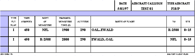
(a) IFR - File two IFR legs or flight plans, one to enter and one to depart the R-2508 Complex. To ensure proper flight plan processing for TRACON, flights not intending to land within the R-2508 Complex should file "R-2508" as the destination in the arrival route of flight and the first fix of the return flight plan/leg, Figure 4-2. Aircraft landing or departing an airport within the R-2508 Complex should file the airport as the destination and/or departure point of the flight plan. The fix of intended entry into the R-2508 Complex, and the fix of intended exit from the R-2508 Complex should be a R-2508 entry/exit fix as listed below, and depicted in Figure 3-8. This does not preclude ATC from clearing aircraft to enter or exit at other R-2508 Complex boundary locations.
EXAMPLE: (See Figure 4-2) for an arrival: NFL..OAL..EWALD..R-2508
for a departure: R-2508..EWALD..OAL..NFL.
Figure 4-2
R-2508 Complex Entry/Exit Points
NAME RADIAL/DME LATITUDE/LONGITUDE
EWALD BTY 274/071 37°12¢00²N/118°07¢48²W
JENID BTY 175/027 36°21¢30²N/116°51¢03²W
HEINY BTY 154/058 35°51¢30²N/116°32¢18²W
HAMBO BTY 283/050 37°12¢00²N/117°38¢33²W
HARNE BTY 274/027 36°55¢30²N/117°10¢33²W
ROSIE PMD 317/015 34°51¢09²N/118°12¢23²W
DAGGS EDW 076/038 34°58¢45²N/116°57¢00²W
CHADS EDW 277/47 35°15¢00²N/118°34¢30²W
ROMOF NID 267/044 35°49¢00²N/118°35¢03²W
MITEL CZQ 086/061 36°41¢15²N/118°34¢23²W
KIOTE NLC 062/068 36°34¢20²N/118°35¢24²W
SWOOP NLC 075/067 36°19¢00²N/118°35¢04²W
* TACAN (NID) un-monitored when China Lake airfield closed.
(b) VFR - Flights may file VFR to the R-2508 Complex boundaries, but must obtain an Work Area clearance from TRACON/SPORT (Figure 3-3) prior to conducting operations in the R-2508 Complex. Advise TRACON/SPORT prior to departing R-2508 Complex airspace.
(2) Flight plan filing does not relieve the aircrew of the responsibility for scheduling appropriate airspace with CCF.
4-7. FLYING PROCEDURES. The R-2508 Complex operational procedures require understanding and familiarity by all Complex users. Due to the Complex's uniqueness, special operating procedures have been established. All users shall be aware of procedures and restrictions as they may have an adverse effect on planned operations. All users of the R-2508 Complex shall comply with the following procedures, unless otherwise coordinated.
a. General.
(1) Users shall be briefed and knowledgeable of R-2508 Complex operating procedures applicable to their mission. COMMANDERS OF UNITS FLYING IN THE R-2508 COMPLEX ARE RESPONSIBLE FOR ENSURING THEIR AIRCREWS ARE PROPERLY BRIEFED. Users include transients to installations located within the R-2508 Complex. CCF shall provide briefings through telephone contact with individual flights or face-to-face briefings for large groups. Civilian aircraft operating under an R-2508 Complex Letter of Agreement (LOA) are required to comply with the operating procedures defined herein, except as modified by the terms of the LOA.
(2) Participating Aircraft. Military aircraft under the command of or sponsored by the Navy, Air Force, or Army members of the JPPB and civilian aircraft under LOA approval of the R-2508 CCB that accept the terms and conditions of the R-2508 Complex briefing.
(3) Non-Participating Aircraft. Military aircraft that cannot comply with the terms of the R-2508 Complex briefing. These aircraft shall be provided IFR services as specified in FAA 7110.65 and FAAO 7610.4 on a non- interference basis. Delays may be expected.
b. Specific Procedures. These operating procedures apply to military aircraft and other authorized flight activities (in accordance with an approved Letter of Agreement) which operate within R-2508, MOAs, ATCAAs, and internal restricted areas as participating aircraft.
(1) All aircraft within R-2508, MOAs or ATCAAs shall operate VFR. If unable to maintain VFR, aircraft shall advise TRACON (call sign "JOSHUA APPROACH"), China Lake Airspace Surveillance Center (ASC) (call sign "CHINA CONTROL") or Edwards AFB Radar Control Facility (call sign "SPORT"/frequency 272.0 MHz/132.75 MHz) and request an amended Work Area clearance from VFR to IFR to reach VFR conditions.
NOTE:
The only condition under which a participating aircraft will be issued an IFR clearance to continue operations within the R-2508 Complex, is if the aircraft encounters weather conditions which are below the minimum for flight under VFR, and the aircrew is unable to proceed under VFR. The purpose of an IFR clearance is to position the aircraft in weather conditions which permit VFR, to exit the area to return to base if unable to locate VFR conditions. After re-encountering VFR weather, the aircrew shall be responsible for canceling IFR clearance.
(2) Operate on the concept of "SEE and AVOID." Scheduling or receiving a clearance to operate within the R-2508 Complex does not constitute exclusive use of the area.
(3) Aircraft shall accept traffic advisories from TRACON, CHINA CONTROL, or SPORT (unless otherwise coordinated). Traffic advisories, safety alerts, and boundary calls shall be issued by controllers on a workload permitting basis.
(a) Aircraft operating in support of R-2505, R-2506, or R-2524 operations will normally be provided radar advisory service by CHINA CONTROL.
(b) Aircraft operating in support of R-2515 operations will be provided radar advisory service by SPORT.
NOTE:
When no longer under control of SPORT or CHINA CONTROL, aircraft shall be advised to contact TRACON to continue operations within the R-2508 Complex or to exit the R-2508 Complex.
(4) All aircraft operating in the R-2508 Complex are required to have an operational transponder and Mode C unless otherwise coordinated. Aircraft shall remain on the ATC assigned transponder code while operating in the R-2508 Complex unless otherwise directed by ATC. The flight leader for standard formation flights will set his transponder for normal squawk and wingman will squawk standby. Upon break-away into elements or individual flights, the element leader or individual aircrew is required to set transponder in accordance with the following:
(a) Advise TRACON of break-away element's call sign(s), number and type aircraft, and request code assignment.
(b) Advise TRACON if traffic calls are required between elements.
(5) Flights shall maintain two-way radio communications with ATC on the appropriate frequency unless otherwise coordinated. It is desired that intraflight communications be carried out on a secondary radio.
c. Operating Procedures.
(1) All aircraft shall obtain a Work Area clearance prior to operating within the R-2508 Complex. The Work Area clearance to operate within the R-2508 Restricted Area MOAs/ATCAAs does not constitute authority to enter Restricted Area R-2502N, R-2502E, R-2505, R-2506, R-2515 or R-2524. It shall be the pilot's responsibility to obtain approval to enter these Restricted Areas from the appropriate Using Agency.
(a) All flights shall contact TRACON on a Work Area frequency (Figures 3-3 and 3-4) prior to Complex entry and exit. Initial contact shall include a request for a Work Area clearance and altitudes.
(b) TRACON will issue appropriate clearances. THIS WORK AREA CLEARANCE ALLOWS FLIGHTS TO OPERATE VFR IN THE R-2508 COMPLEX. As with any Work Area clearance, aircrews are responsible for remaining within the vertical and lateral confines defined by the clearance. If the aircraft leaves the vertical or lateral confines of the clearance a flight violation may be filed. Aircrews issued Work Area clearance altitudes lower than mission requirements should request higher from TRACON. Some delay may be encountered for higher altitude.
Active/Inactive monitoring is dependent upon availability of radio resources at TRACON.
(a) Active Monitoring. TRACON tune transceiver to mission frequency requested, listen on the frequency, and make traffic/boundary calls on mission frequency. Continuous direct pilot to controller communications on mission frequency.
(b) Inactive Monitoring. TRACON tune transceiver to mission frequency requested but do not listen on frequency. Traffic and boundary calls will be made on mission frequency as needed. Direct pilot to controller communications require pilot switch to ATC frequency (i.e., amended clearances, aircrew request, or prior to exiting the R-2508 Complex).
(8) Aircraft not operating on a mission/tactical frequency shall, unless otherwise advised, monitor the appropriate work area ATC discrete frequency (Figures 3-3 and 3-4).
(9) Maneuvering Areas
(a) When using Maneuvering Areas (Figure 4-1) for ACM or any other mission requiring extensive maneuvering, advise TRACON of the area. When conducting ACM, aircrews should be aware of noise sensitive areas that must be avoided to the maximum possible extent, see paragraph 3-3.c.
(b) When transiting Maneuvering Areas en route to work areas or RTB, make every effort to use ridgeline transit routes (Figure 4-1) or fly below 5000' AGL to deconflict with possible maneuvering activities.
(10) Low Level Flying
(a) Low level flying activities are conducted at altitudes below the radar horizon and in areas with marginal communications coverage. This reduces the ability of TRACON to provide traffic advisories.
(b) To assist aircrews in avoiding traffic conflicts, a dedicated low level UHF frequency, 315.9 MHz, has been established. In the interest of safety, it is strongly suggested that aircrews utilize this frequency when operating in the low level structure, especially when approaching ridge crossings or the saddle at Hunter Mountain between the Panamint and Saline MOAs.
The procedures for using this frequency are similar to UNICOM in concept
and allows an aircrew to inform other aircrews of their mission and intentions,
and to coordinate/deconflict as necessary. THIS FREQUENCY IS NOT
MONITORED BY TRACON.
(c) Procedures. The following procedures have been implemented to enhance flight safety within the R-2508 Complex and should be used by aircrews involved in sustained flight at low altitudes.
1 All aircraft engaged in low level flying should monitor 315.9 MHz when engaged in flight activities below 1500' AGL in the R-2508 Complex work areas.
2 Aircrews shall check in and out on an ATC frequency (Figures 3-3 and 3-4) with TRACON and request to change to the low level frequency. Dual radio aircraft shall continue to monitor appropriate ATC or mission frequency.
3 Calls will be made in the blind using call sign, number and type aircraft, area entering/departing, and direction of flight.
4 Transmissions on the low level frequency are normally confined to:
a Initial check in when entering Panamint, Saline, Owens, and Kern River Valleys; Owens Dry Lake; and Walker Pass.
b Calls necessary to deconflict traffic when two missions are operating in the same area.
c Checking out of an area or from low level flight.
5 In cases where multi-ship flights include aircraft equipped with a single radio, one aircraft should be equipped with multiple radios. This aircraft is responsible for monitoring the low level frequency and providing the necessary coordination to the single radio aircraft in the flight to deconflict the flight's activities with other aircraft operating in the area.
a. Scheduling Requirements. Guidelines for operating UAVs are contained in Appendix E. Basically, UAVs may be authorized to operate within R-2508 Complex on a case by case basis. Contact the appropriate scheduling agency (see paragraph 4.1) for the affected restricted area(s) where you desire to operate a UAV. Contact the R-2508 Central Coordinating Facility to coordinate operations in the work areas or R-2508.
b. Work Area Clearance. Chase aircraft pilots are required to obtain
the appropriate Work Area clearance, and monitor the appropriate ATC frequency
for traffic advisories and boundary calls.
OPERATING PROCEDURES
5-1. R-2502 N/R-2502E, NATIONAL TRAINING CENTER, FT IRWIN.
a. Area Description - R-2502N/R-2502E consists of five separate areas (Figure 5-1):
(1) Southern Engagement Corridor. Force-on-Force battle simulation area.
(2) Central Engagement Corridor. Force-on-Force battle simulation area.
(3) Live Fire Exercise Corridor. This area contains computerized, pop-up, direct fire artillery and close air support targets. During Live Fire Exercise, actual battle conditions are closely simulated with artillery fire, tanks, and troops advancing against the computerized arrays supported by attack helicopters and with jet aircraft close air support targets.
(4) Leach Lake Air Gunnery Range. This range is used for maneuvering by Army, Air Force, and Navy flying units providing Close Air Support (CAS) during rotational periods. Live/inert ordnance may only be dropped in support of NTC rotations. During non-rotational periods overflight of Leach Lake must be scheduled as outlined in paragraph 4-1c. Leach Lake is located in the northern portion of R-2502N and is defined by the following coordinates:
Beginning at 35°30¢40²N/116°55¢33²W
thence direct 35°32¢40²N/116°30¢03"W
thence direct 35°38¢N/116°30¢03"W
thence direct 35°38¢40²N/116°55¢36²W
thence direct to point of beginning.
(5) Goldstone Deep Space Tracking Facility. The Goldstone Facility is an area of intense electromagnetic and other radiation hazards that must be avoided. The facility lies on the western boundary of R-2502N (Figure 5-1). Overflight is to be avoided below 15,000' MSL. Overflight above 15,000' MSL must be coordinated with the R-2508 CCF (see FLIP AP1, "Flight Hazards", California, for further information).
b. Command and Control Facilities. Initial contact with Army Flight Following Service is required prior to entering R-2502N or R-2502E.Aircraft must be in contact with and under the control of one of the following agencies:
(1) Army Flight Following Service (AFFS), Ft Irwin. AFFS (call sign "Desert Radio") is the primary control facility for R-2502N and R-2502E. AFFS is operational 24 hours a day 7 days a week and their frequencies are UHF 241.0, VHF 126.2, and FM 41.50.
(2) NTC Ft Irwin Airspace Control Center (NACC/Sundance). NTC Ft Irwin Airspace Control Center (NACC/Sundance) is a multi-function Air Force element that serves as a focal point for close-air support activities. Functions include airspace procedural control and direct airspace coordination/deconfliction with Operations Group and Desert Radio AFFS. The NACC has UHF, VHF, and FM radios available and is manned one hour prior to the first time-on-target until 30 minutes past the last flight's departure from R-2502N/R-2502E, or as required. If a flight is approved and the NACC is not operating, contact Desert Radio AFFS.
c. Scheduling. Requests for use of ranges and training areas will be submitted to Range Scheduling no later than 5 working days prior to the desired use date. All aircraft operations within R-2502N and R-2502E require coordination with Bicycle Lake AAF Operations. PPRs shall be obtained 72 hours in advance to allow for required coordination. PPRs may be obtained by contacting Bicycle Lake AAF Operations, DSN 470-4320/6816. CONTACT CCF TO SCHEDULE THE MOAs FOR ENTRY/EXIT.
d. Special Procedures. Air Warrior Aircrews deploying in support of NTC Ft Irwin exercises will receive a local orientation briefing before conducting NTC Ft Irwin operations. The briefing is conducted by the 549 JTS at Nellis AFB (DSN 682-4262/4060/5561). Familiarization rides in R-2502 N/R-2502E will be flown in Southern/Central/Live Fire Corridors before CAS missions are flown. All helicopter aircrews shall be briefed, by the NTC Installation Safety Officer, prior to flight in R-2502N and R-2502E.
(1) Coordination Altitudes. Coordination altitudes in R-2502N/R-2502E are 200'/300' AGL. Fixed wing aircraft will remain above 300' AGL unless specific authorization has been obtained from Bicycle Lake Operations. Helicopters will remain below 200' AGL unless coordinated and approved by Bicycle Lake Operations and NACC.
Additional restrictions are as follows:
(a) Overflight of helicopter routes by fixed wing aircraft will be above 300' AGL. Helicopter administrative routes parallel paved roads with some exceptions (Figure 5-1).
(b) Overflight of Goldstone area must be coordinated with CCF.
(c) Overflight of NTC Ft Irwin cantonment and Ammo Supply Point (NU292984) is prohibited.
(d) Overflight of Bicycle Lake AAF with ordnance is prohibited.
(e) Overflight of Bicycle Lake AAF by fixed wing aircraft is restricted to above 5,500¢ MSL unless coordinated and approved by Desert Radio. Air Warrior aircraft may request approval through Sundance.
(2) Helicopter Operations. All helicopter entries will be coordinated by PPR and a briefing will be given at that time on entry procedures. All exercise helicopters will land at Bicycle Lake AAF for a local area briefing prior to further flight on the reservation. This briefing must be coordinated and scheduled in advance. Helicopters will monitor at least one Desert Radio frequency at all times and will be provided with current range and fixed wing traffic information as well as flight following service.
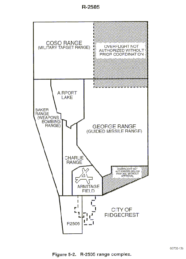
5-2. R-2505, NAVAL AIR WARFARE CENTER WEAPONS DIVISION, CHINA LAKE.
a. Area Description. Restricted Area R-2505 is restricted from surface to unlimited on a continuous basis and is subdivided into five primary ranges (Figure 5-2). The primary mission of these ranges is the Research, Development, Test and Evaluation (RDT&E) of weapons and weapons systems. Located within R-2505 are six bombing ranges, one guided missile range, and numerous ground ranges and arenas. The six bombing ranges contain instrument targets for air-to-surface, air-to-air, and surface-to-air firings. Remotely piloted aircraft (NOLOs) are sometimes used as targets. The target complex in the COSO and BAKER ranges contain targets for air-to-surface bombing and strafing by fleet and development activities. A rocket engine test complex and explosives test complex for experimental rocket engines and warheads occupies the southeast corner of the GEORGE Range complex. A parachute drop area is also located in GEORGE Range. Armitage Airfield is located within the southern part of the R-2505 ranges and requires specific entry and departure procedures to avoid restricted range activities (FLIP AP1).
b. Command and Control. The separate ranges within R-2505 each have a designated mission frequency. Depending on the type mission, range controllers will either monitor the mission or provide precision vectors and range asset coordination. All aircraft using R-2505 ranges will check in with Airspace Surveillance Center (ASC), call sign "CHINA CONTROL" on appropriate frequency. CHINA CONTROL will advise the aircraft to contact the appropriate test conductor and will continue to monitor the frequency and provide radar advisory service.
c. Scheduling.
(1) Requests for use of R-2505 will be made to the Test Management Office (see paragraph 4-1) or by message in accordance with NAWCWPNSINST 3710.5. A Test Manager will be assigned to coordinate approval for the requested use. Test Manager support will include the following, as appropriate:
(a) Development and approval of a test plan.
(b) Guidance pertaining to reimbursement costs for China Lake support.
(c) Scheduling of appropriate China Lake airspace and range assets.
NOTE:
Aircrews are responsible for scheduling required R-2508 Complex Work Areas with the CCF.
(d) Scheduling of airspace, range, and course rules briefing as required.
(2) Requests for use of R-2505 (airspace use only) should be directed to the Range Scheduling Office (paragraph 4-1.). All aircrews scheduled to operate in R-2505 must receive a range briefing prior to operating in R-2505.
d. Special Procedures.
(1) PPRs are necessary to land at Armitage Field. To obtain a PPR and to arrange for transient support services, contact the NAWS China Lake Fleet Liaison Office (DSN 437-5523/5464).
(2) Transit to/from R-2505 and Armitage Airfield requires scheduling and receipt of a Work Area clearance (Chapter 4).
5-3. R-2506, NAVAL AIR WARFARE CENTER WEAPONS DIVISION, CHINA LAKE.
a. Area Description. R-2506 is restricted from the surface to 6,000¢ MSL (1400' to 3700' AGL from the highest and lowest obstructions, respectively) from sunrise to sunset, Monday through Friday (Figure 5-2). The primary mission is to provide airspace to maneuver for high-speed, low altitude run-in flights to targets located within R-2505. This area is also used to route noise-abatement departures from Armitage Field on a non-interference basis.
b. Command and Control. Radar advisory service for R-2505 range activities utilizing R-2506 is provided by the China Lake ASC (CHINA CONTROL/frequency 301.0 MHz).
c. Scheduling. R-2506 is scheduled in accordance with procedures assigned for R-2505 (paragraph 4-1).
d. Special Procedures. For real-time transit of R-2506, contact CHINA CONTROL on 301.0/128.25 MHz or if unable, contact CHINA LAKE TOWER on 340.2/120.15 MHz.
5-4. R-2524, NAVAL AIR WARFARE CENTER WEAPONS DIVISION, CHINA LAKE.
a. Area Description.
(1) Restricted Area R-2524 is restricted from surface to unlimited on a continuous basis and encompasses the Electronic Combat Range (ECR), Superior Valley, and the Mojave B North target area (Figure 5-3).
(2) The ECR with its complexes known as ECHO Range, is located throughout the restricted area R-2424 and provides a simulated hostile land and sea surface-to-air weapons installation. The instrumented range supports Research and Development, Operational Test and Evaluation, Radar Warning Receiver (RWR) systems, Anti-Radiation Missile (ARM) systems, and EW training. Most ECHO missions require full use of R-2524.
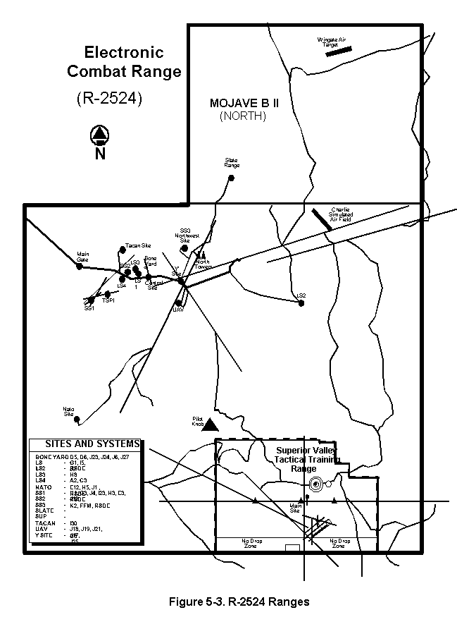
(3) Mojave B North target area (located in the northern part of R-2524) contains two convoy targets and a simulated airfield with aircraft targets that are for use with inert ordnance only.
b. Command and Control. ECHO provides a test team for control of test/mission aircraft and control of ground-based threat simulation in accordance with test parameters. All aircraft utilizing R-2524 ranges will check-in with the China Lake Airspace Surveillance Center, call sign CHINA CONTROL on appropriate frequency. CHINA CONTROL will hand-off aircraft to the appropriate range controller and will continue to monitor the flight and provide radar advisory service. Additional control for Mojave B North consists of a ground or airborne safety observer.
c. Requests and Scheduling.
(1) Requests for use of ECHO will be made by contacting the ECR Test Operations Branch (paragraph 4-1) or by message in accordance with NAWCWPNSINST 3710.5.
(2) Request for use of R-2524 (airspace only) should be forwarded directly to the ECR Scheduling Office (paragraph 4-1). Real-time requests for overflight may be made through the TRACON (JOSHUA APPROACH).
(3) In all cases (except requests for airspace only) a Test Manager will be assigned to coordinate and obtain approval, as appropriate. The Test Manager will aid in the development of a test plan, provide range cost information, and coordinate scheduling of airspace and range assets.
d. Special Procedures. R-2524 is bordered on the south and east by other restricted areas and on the west and north by Panamint MOA/ATCAA. Normal transit to/from R-2524 through adjacent Complex airspace requires appropriate scheduling and approval in accordance with procedures outlined in Chapter 4. Refer to appropriate procedures outlined in this chapter for transit coordination for other restricted areas.
NOTE:
Aircrews are responsible for scheduling required R-2508 Complex Work Areas with the CCF.
5-5 R-2524 SUPERIOR VALLEY TACTICAL TRAINING RANGE, NAVAL AIR WARFARE CENTER WEAPONS DIVISION, CHINA LAKE
a. Area Description.
(1) The Superior Valley Tactical Training Range (Figures 5-3 & 5-4), is situated within R-2524 and is located 41 miles southeast of the main Naval Air Weapons Station
(NAWS) complex. The Range is operated by the Naval Air Warfare Center Weapons Division (NAWCWPNS), Electronic Combat Range (ECR), and has approximately 76 square miles of secluded land and airspace. The area is restricted from surface to unlimited on a continuous basis. Superior Valley coordinates are:
Beginning at 35°15¢56²N/117°12¢27²W;
thence direct 35°25¢00²N/117°12¢27²W;
thence direct 35°25¢00²N/116°55¢23"W;
thence direct 35°15¢56²N/116°55¢23²W;
thence direct to point of beginning.
(2) The Superior Valley Tactical Training Range has over 60 diverse targets, including surface-to-air missiles (SAMs), antiaircraft artillery (AAA), and convoy targets. All targets are available for inert ordnance delivery only. The Range consists of a Range Operations Center, a main control tower, two flank towers, a photovoltaic power production facility, a helicopter pad, a target storage facility, and four main targeting areas. They are: the Northwest Target Complex, the Conventional and Alternate Bombing Circles, the Southeast Airfield Target Complex and the Low-/High-Angle Strafe Pit. This range will be fully scored in FY97.
b. Command and Control.
The Range Control Officer (RCO) controls range entry and departures, supervises air operations, monitors safety, and allocates the use of the target complexes within the Range.
c. Requests and Scheduling.
(1) The ECR Test Operations Branch will schedule all daily activity at the Superior Valley Range. The normal working hours of the ECR are Monday through Thursday, 0630 (L) -1630 (L). Scheduling of range periods for U.S. Navy Fleet users will be provided by SFWSP, NAS Lemoore, California to the ECR Test Operations Branch 10 days before the week requested. NAS Lemoore squadrons will have priority up to the 10-day deadline. Remaining range periods will be made available to other agencies after the 10-day deadline. Cancellations should be made no later than 48 hours before the flight. Scheduling of Superior Valley does not include the remaining R-2524 airspace. Requests for use of R-2524 airspace will be coordinated on a not-to-interfere basis.
(2) Request for use of R-2524 assets in conjunction with Superior Valley must be coordinated with an ECR Test Manager.
a. Area Description.
(1) Restricted Area R-2515 (Figure 5-5) is restricted from the surface to unlimited on a continuous basis. The area encompasses Edwards AFB and extends north and east to the borders of R-2524 and R-2502N.
(2) R-2515 contains various instrument ranges and special use areas (i.e., Spin Areas, Supersonic Corridors, Drop Zones, etc.). The area is used for a variety of flight test operations which require a high degree of eyes-in-the-cockpit flying. UAV's are also flown in the area.
(3) Each aircrew is responsible for remaining clear of special use areas. This requires detailed knowledge of the area and is the basis for outside users being briefed and scheduled. Detailed descriptions of the various special use areas are provided in AFFTC Instruction 11-1. A copy may be obtained from the Airspace Manager (paragraph 4-1).
b. Air Traffic Control Services.
(1) SPORT, frequency 272.0/132.75 MHz, provides radar traffic and safety advisories to all participating aircraft within R-2515. Pre-mission briefing is required with SPORT, DSN 527-3928/3931, prior to flying test missions or using special use areas within R-2515.
(2) Mission details must be thoroughly coordinated to ensure adequate briefings are obtained concerning airspace use and scheduled mission profiles.
c. Scheduling.
(1) Repeated use of R-2515 airspace to conduct flight operations or transit, requires a Letter of Agreement with AFFTC. Limited periods of use may be permitted without formal written agreement when deemed appropriate by AFFTC. The initial coordination POC is the R-2515 Airspace Manager, DSN 527-2446 (paragraph 4-1).
(2) Requests for scheduled crossing of R-2515 may be directed to the AFFTC Scheduling Office, DSN 527-4110 (paragraph 4-1).
(3) All non-assigned aircraft, military or civilian, with a requirement to operate from Edwards AFB on any type of support mission, regardless of agency or project being supported, must contact the AFFTC/XR (by message or phone DSN 527-3837 or 661-277-3837) at least 20 days prior for approval and assignment of a sponsor/project officer.
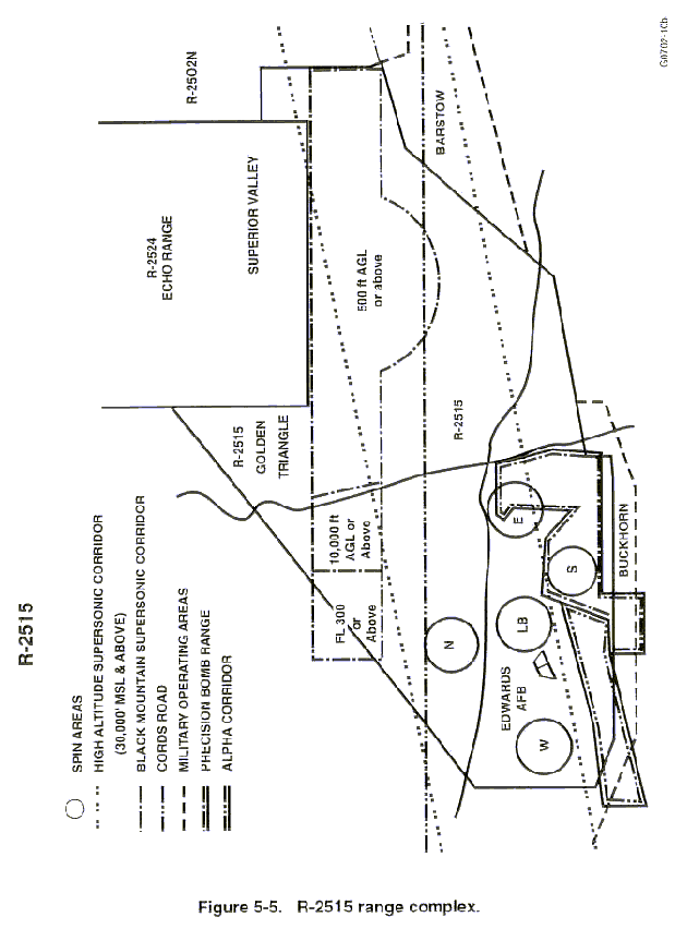
(4) Special use areas (i.e., Supersonic Corridor, Spin Areas, Alpha Corridor, Precision Impact Range Area, and Aerial Refueling Area) may be scheduled for use by non-AFFTC users. An airspace briefing from the R-2515 Airspace Manager is required. Availability is based upon higher priority AFFTC missions. Some reimbursable cost may be imposed.
d. Special Procedures.
(1) A PPR is required for landing at Edwards AFB. To obtain a PPR and airspace briefing, contact Edwards AFB Base Operations (DSN 527-2222 or 661-277-2222). Consult FLIP AP/1 for further restrictions and information for landing at Edwards AFB. Also, an R-2508 Complex briefing may be obtained from the CCF, DSN 527-2508 or 661-277-2508.
(2) Participating aircraft are VFR crossing the R-2515 boundary.