HIGH
FREQUENCY
ACTIVE
AURORAL
RESEARCH
PROGRAM
Please
Visit the Home Page for HAARP

What Is HAARP?
HAARP (High frequency Active
Auroral Research
Program) is to be a major Arctic facility for upper atmospheric
and solar-terrestrial research. HAARP is being built on a DoD-owned site
near Gakona, Alaska. Principal instruments include a high power, high-frequency
(HF) phased array radio transmitter (known as the Ionospheric Research
Instrument, or IRI), used to stimulate small, well-defined volumes of ionosphere,
and an ultra-high frequency (UHF) incoherent scatter radar (ISR), used
to measure electron densities, electron and ion temperatures, and Doppler
velocities in the stimulated region and in the natural ionosphere. To further
the scientific capabilities and usefulness of the IRI and ISR, HAARP is
supporting the design and installation of the latest in modern geophysical
research instruments, including an HF ionosonde, ELF and VLF receivers,
magnetometers, riometers, a LIDAR (LIght Detection And Ranging) and optical
and infrared spectrometers and cameras which will be used to observe the
complex natural variations of Alaska's ionosphere as well as to detect
artificial effects produced by the IRI.
Is HAARP Unique?
Ionospheric research facilities have been in continuous use since the 1950's
to investigate fundamental physical principles which govern the earth's
ionosphere, so that present and future transmission technologies may take
into account the complexities of the ionosphere. At the present time the
US operates two ionospheric research sites, one in Puerto Rico, near the
Arecibo Observatory, and the other (known
as HIPAS) in Alaska near Fairbanks.
Both of these employ active and passive radio instrumentation similar to
that being built at HAARP. Interest in the ionosphere is not limited to
the US: a five-country consortium operates the European Incoherent Scatter
Radar site (EISCAT), a
premier world-class ionospheric research facility located in northern Norway
near Tromsø. Facilities also are located at Jicamarca, Peru; near
Moscow, Nizhny Novgorod ("SURA") and Apatity, Russia; near Kharkov, Ukraine
and in Dushanbe, Tadzhikistan. All of these installations have as their
primary purpose the study of the ionosphere, and most employ the capability
of stimulating to a varying degree small, localized regions of the ionosphere
in order to study methodically, and in a detailed manner what nature produces
randomly and regularly on a much larger scale. HAARP also will have such
a capability, but what sets HAARP apart from existing facilities is the
unusual combination of a research tool which provides electronic beam steering,
wide frequency coverage and high effective radiated power collocated with
a diverse suite of scientific observational instruments.
Who is Building HAARP?
Technical expertise and procurement services as required for the management,
administration and evaluation of the program are being provided cooperatively
by the Air Force (Air Force Research Laboratory) and Navy (Office of Naval
Research and Naval Research Laboratory). Since HAARP consists of many individual
items of scientific equipment, both large and small, there is a considerable
list of commercial, academic and government organizations which are contributing
to the building of the facility by developing scientific diagnostic instrumentation
and by providing guidance in the specification, design and development
of the IRI. Advanced Power Technologies, Inc. (APTI), an employee-owned
company, was awarded the contract to design and build the IRI, based on
a proposal submitted in response to an RFP issued by the Office of Naval
Research in 1992, and published in the Commerce Business Daily. Other organizations
which have contributed to the program include the University of Alaska,
University of Massachusetts, UCLA, MIT, Stanford University, Dartmouth
University, Clemson University, Penn State University, University of Tulsa,
University of Maryland, Cornell University, SRI International, Northwest
Research Associates, Inc., and Geospace, Inc.
What is the Value of Ionospheric Research?
The ionosphere begins approximately 35 miles above the earth's surface
and extends out beyond 500 miles. In contrast to the dense atmosphere close
to the earth, which is composed almost entirely, of neutral gas, the thin
ionosphere contains both neutral gas and a small number of charged particles
known as ions and electrons. This ionized medium can distort, reflect and
absorb radio signals, and thus can affect numerous civilian and military
communications, navigation, surveillance and remote sensing systems in
many varied ways. For example, the performance of a satellite-to-ground
communication link is affected by the ionosphere through which the signals
pass. AM broadcast programs, which in the daytime can be heard only within
a few tens of miles from the station, at night sometimes can be heard hundreds
of miles away, due to the change from poor daytime to good nighttime reflection
from the ionosphere. A long-range HF communication link which uses multiple
hops or reflections from the ionosphere and ground, often experiences amplitude
fading caused by interference between signals which have traveled from
the transmitter to the receiver by two (or more) different ionospheric
paths.
Since the sun's radiation creates and maintains the ionosphere, sudden
variations in this radiation such as those caused by solar flares can affect
the performance of radio systems. Sometimes these natural changes are sufficient
to induce large transient currents in electric power transmission grids,
causing widespread power outages. Lightning is known to cause substantial
heating and ionization density enhancement in the lower ionosphere, and
there are indications that ground-based HF transmitters, including radars
and strong radio stations, also modify the ionosphere and influence the
performance of systems whose radio paths traverse the modified region.
Perhaps the most famous example of the latter is the "Luxembourg" effect,
first observed in 1933. In this case a weak Swiss radio station appeared
to be modulated with signals from the powerful Luxembourg station, which
was transmitting at a completely different frequency. Music from the Luxembourg
station was picked up at the frequency of the Swiss station.
The continual growth in the number of civilian and military satellite
systems whose performance depends on paths passing through the ionosphere,
encourages not only good characterization and monitoring of the ionospheric
state, but also an examination of what controlled local modification of
the ionosphere, using ground HF transmitters, could do for and to these
systems. Thus, while the HAARP facility is expected to provide significant
advancements in understanding ionospheric science by stimulating and controlling
plasma processes in a tiny localized region within the ionosphere, it also
has the potential for significantly affecting the planning for future satellite
communication and navigation systems through improvements in reliability
and economics.
Why is the DoD Involved?
The Department of Defense (DoD) conducts Arctic research to ensure the
development of the knowledge, understanding and capability to meet national
defense needs in the Arctic. Interest in ionospheric research at HAARP
stems both from the large number of communication, surveillance and navigation
systems that have radio paths which pass through the ionosphere, and from
the unexplored potential of technological innovations which suggest applications
such as detecting underground objects, communicating to great depths in
the sea or earth, and generating infrared and optical emissions. Expanding
our knowledge about the interactions of signals passing through or reflecting
from the ionosphere can help to solve future problems in the development
of DoD systems, and could as well enhance the utilization of commercial
systems which rely on the expedient transfer of real-time communications.
Why Gakona, Alaska?
During HAARP's environmental impact study, Gakona was identified as one
of two DoD-owned, Alaskan locations which satisfied the site selection
criteria of being within the auroral zone, near a major highway for year-round
access, away from densely settled areas, of sufficient size to allow for
equipment siting and separation space, on relatively flat terrain, of realistic
and reasonable construction and operation costs as well as minimal environmental
impacts. On October 18, 1993 following the July 15, 1993 issuance of the
Air Force's Environmental Impact Statement which evaluated potential environmental
effects of constructing and operating the HAARP facility, a Record of Decision
(ROD) signed by the Deputy Assistant Secretary of the Air Force for Installations
selected Gakona as the location for the HAARP facility.
Location of the HAARP Facility
The access road is located at Milepost 11.3 on the Tok highway. The geographic
coordinates of the HF antenna array array are approximately 62.39 degrees
(North) latitude, 145.15 degrees (West) longitude.
The geomagnetic coordinates for the facility are 63.09 degrees (North)
latitude and 92.44 degrees (West) longitude.
What is the IRI and what does it transmit?
Basically, the IRI is what is known as a phased array transmitter. It is
designed to transmit a narrow beam of high power radio signals in the 2.8
to 10 MHz frequency range. Its antenna will be constructed on a 1000' x
1200' gravel pad (about 33 acres). There are to be 180 towers, 72' in height
mounted on thermopiles spaced 80' apart in a 12 x 15 rectangular grid,
each of which supports near its top, two pairs of crossed dipole antennas,
one for the low band (2.8 to 8.3 MHz), the other for the high band (7 to
10 MHz). The antenna system is surrounded by an exclusion fence to prevent
possible damage to the antenna towers or harm to large animals. An elevated
ground screen, attached to the towers at the 15' level, acts as a reflector
for the antenna array while allowing vehicular access underneath to 30
environmentally-controlled transmitter shelters spaced throughout the array.
Each shelter will contain 6 pairs of 10 kW transmitters, for a total of
6 x 30 x 2 x 10 kW = 3600 kW available for transmission. The transmitters
can be switched to drive either the low or high band antennas. Electric
prime power will be obtained from six, 2500 kW generators, each driven
by a 3600 hp diesel engine. From a control room within the Operations Center
the transmissions from each dipole can be adjusted in amplitude and phase
so as to form a narrow antenna pattern pointed upward toward the ionosphere.
The transmitted signal diverges (or spreads out) as it travels upward and
is partially absorbed, at an altitude which depends on the HF frequency,
in a small volume several tens of miles in diameter and a few hundred meters
thick directly over the facility. The remainder of the transmitted signal
either reflects back toward the earth or passes through the ionosphere
into space, continuing to diverge as it does so. By the time it reaches
the ionosphere, the intensity of the HF signal is less than 3 microwatts
(0.000003 watt) per cm2, tens of thousands of times less than the Sun's
natural electromagnetic radiation reaching the earth and hundreds of times
less, even, than the variations in intensity of the Sun's natural ultraviolet
(UV) energy which creates the ionosphere.
How safe are these transmissions?
Because the antenna pattern of the IRI array has been tailored to transmit
its signal upward rather than toward the horizon, radio field strengths
at ground level, including areas directly under the antenna array, are
calculated to be smaller than Radiofrequency Radiation (RFR) standards
allow for human exposure. This is possible because the individual transmitters
are spaced apart over 33 acres so that the concentration of radio fields
never
exceeds these nationally recognized safety standards. Radio field strengths
on the ground around the array have been measured throughout the construction
of the facility, beginning in 1994 and will continue through all future
construction to ensure that all requirements for safety mandated in the
EIS Record of Decision are met. At the point of closest public access on
the Tok Highway, for example, the measured fields are ten-thousand times
smaller than permitted by the RFR standards and hundreds of times smaller
than typically found near AM broadcast station antennas in many urban areas.
The strength of these fields continues to decrease in a rapid manner at
greater distances from the facility.
What about aircraft?
While the signals along the ground are well-below adopted safety levels,
the signals transmitted above the antenna array may have sufficient strength
to interfere with electronic equipment in aircraft flying nearby. Therefore,
to ensure the safety of all flight operations in the vicinity of HAARP,
an aircraft
alert radar (AAR) will automatically shut off appropriate transmissions
when aircraft are detected either within or approaching a defined safety
zone around the facility. Flight tests conducted using a Piper Super Cub
demonstrated the capability of the HAARP radar to detect even very small
targets. Ensuring correct operation of the AAR will be a prelude to starting
high power transmissions.
What is the potential for Radio Frequency Interference (RFI)?
Every radio transmitting facility has the potential to interfere with other
radio spectrum users. To determine the potential for HAARP's transmissions
to interfere inadvertently with other spectrum users such as Alaskan TV,
AM/FM radio, ham radio, or even with HAARP's own sensitive radio receiving
equipment, a comprehensive RFI study was conducted during the environmental
impact study phase. Theory predicted that in several worst-case scenarios,
interference may be encountered by some nearby users sharing the RF spectrum.
On the other hand, the real world experiences of similar ionospheric research
instruments and radar diagnostics employed elsewhere in the world have
shown that compatible operations are practical. Included in HAARP's frequency
application to the Spectrum Planning Subcommittee of the National Telecommunications
and Information Administration (NTIA) is the commitment to a mitigation
program that includes acquisition of state-of-the-art transmitters
with stringent requirements for minimizing out-of-band transmissions; proper
orientation of the HF antenna array and adoption of operating procedures,
including beam steering, to minimize array sidelobes; employing special
techniques such as waveform shaping, filtering and antenna null placement;
and working with affected spectrum users, if any, to reach mutually agreeable
solutions. A local phone number (907) 822-5497 permits anyone believing
they have interference from HAARP to contact the Gakona site operations
center.
What is the RFI Resolution Advisory Committee?
The Record of Decision stipulated than an RFI Resolution Advisory Committee
("Committee") would be formed with local representation, to help mitigate
potential RFI issues. The local community-appointed resident would serve
as an ombudsman to ensure community satisfaction with the RFI mitigation
approaches undertaken by HAARP. The purpose of the Committee is to provide
a forum for the thorough review of confirmed RFI reports. Four Committee
meetings have taken place so far, on December 6, 1994, July 1995, August
1996 and August 1997. Committee members are from the following organizations
(one from each): Community-appointed resident, Aircraft Owners and Pilots
Association (AOPA), ALASCOM, Alaska Department of Environmental Conservation,
Alyeska Pipeline Service Co., American Radio Relay League (ARRL), Coast
Guard, Federal Aviation Administration (FAA), Fish & Wildlife (Federal),
Fish & Game (State), National Park Service, HAARP Environmental Liaison
Officer, HAARP operational staff (site supervisor or delegate), HAARP Program-appointed
chairperson, National Park Service, Naval Research Laboratory (NRL), and
the combined Alaska military command (ALCOM) frequency coordinator.
To ensure that all concerns, including aircraft safety as well as radio
frequency interference issues, are addressed completely before the IRI
operates at full power, a Developmental
Prototype (DP) was constructed and operated at the Gakona site. A 6
x 8 (48 antenna element) array of crossed dipole antennas was built at
the NE corner of the planned 12 x 15 antenna field. A 3 x 6 subset of these
antennas was energized by 18 pairs of 10 kW transmitters contained in three
separate shelters, thus supplying up to a maximum of 360 kW. Prime power
for this initial array was obtained from three 350 kW diesel generators.
During 1998, the DP was upgraded to include transmitters for all 48
of the antenna elements that were originally installed. This Filled
Developmental Prototype (FDP) will be capable of producing 960 kW of
total transmitter power. Calculations of expected HF fields in the vicinity
of the FDP antenna array show that field intensities everywhere, including
within the FDP beam, are below recommended international safety limits
for fly-by-wire aircraft. Nonetheless, the FDP will be energized only when
the aircraft alert radar is operating, to insure that no high power transmissions
occur when there is local flight traffic. Operation and test of the FDP
will verify the system design, identify any radio frequency interference
problems resulting from spurious and/or harmonic emissions and permit mitigation
measures to be tested and employed, if necessary.
HAARP Diagnostics
HAARP is developing an extensive set of diagnostic
instrumentation to support ionospheric research at auroral latitudes,
to characterize the processes produced in the upper atmosphere and ionosphere
by high power radio waves and to assess the potential of ionospheric modification
technology for DoD applications. While some of these scientific instruments
will be collocated with the IRI at the research facility, others, due to
geometrical considerations, must be located off-site at various distances
from the facility. One of the primary active on-site instruments will be
the incoherent scatter radar (ISR) which will transmit radiowave signals
in the 430 - 450 MHz band. Another is the HF ionosonde, which transmits
in the 1-30 MHz band and is used to provide scientists with information
about the electron density profile in the ionosphere.
Passive on-site instruments include a magnetometer for the measurement
of the earth's magnetic field and its variations, and a riometer (relative
ionospheric opacity meter) to sense ionospheric absorption of the celestial
background electromagnetic radiation. The radio spectrum from 100 kHz to
1 GHz is being recorded to determine frequency of usage and to monitor
HAARP transmissions to ensure adherence to FCC and NTIA requirements. Data
obtained from these scientific instruments are being combined into an integrated
data package for access worldwide on the internet in near real time, allowing
scientists to observe and participate in the investigations directly from
their laboratories. HAARP is participating in the National Science Foundation's
Upper Atmosphere Research Collaboratory (UARC) Telescience program being
developed at the University of Michigan. In addition to the instruments
specifically developed by HAARP, a number of diagnostics potentially are
available through other federal agencies and the University of Alaska's
Geophysical Institute.
Use of Local Resources
The Geophysical Institute of the University of Alaska Fairbanks (UAF) has
played a major role in the development of diagnostics and coordination
of Arctic programs with the US scientific community. UAF led a consortium
of universities and industries which provided support in the design and
development of the Gakona facility and its associated scientific instruments.
Advanced Power Technologies, Inc. (APTI), the prime contractor for the
IRI, utilized Eric Goozen for initial site survey work. APTI employed a
Glennallen-based company, Ahtna Construction, Inc., which subcontracted
to Cruz, Survey Alaska and Double S Trucking for clearing and constructing
the DP gravel pad. Recently, Ahtna was the subcontractor for the access
road extension. Ahtna also is providing nightly security coverage. Anchorage-based
engineering firms Duane Miller & Associates and USKH prepared the civil
and pad design work and conducted the on-site testing and evaluation. Arctic
Foundation of Anchorage designed and manufactured, and Kiewit Pacific Company
installed thermopiles in the pad, using Amtec, Inc. to survey the thermopile
locations and Tester Drilling and EBA Engineering to provide drilling support.
Acme Fence Company installed fencing, using the services of Mark Lappi
to survey the fence lines and B&B Plumbing to steam thaw the ground
for drilling. City Electric, Inc. erected the towers, antennas, and ground
screen. Pacific Detroit Diesel provided diesel generators for the DP phase
and has refurbished, installed and tested the first 2.5 MW diesel generator
which will be used to power the HF transmitters. Service Oil delivered
and placed the 5000 gallon DOT-approved tanker. Copper Valley Telephone
installed the telephone lines, and Copper Valley Electric supplies commercial
housekeeping power. Newbery Alaska installed the electrical distribution
lines and provided the pole for the aircraft alert radar antenna. Bishop
& Sons Enterprises supplies water, while CBS Service provides trash
removal and sewage disposal. Harley McMahon flew sorties to test the capabilities
of the aircraft alert radar and provide the opportunity for aerial photography.
Current/Future Operations at the HAARP Research Facility
Completing the Development Prototype testing is the primary goal of the
current operations at HAARP. Initial DP testing began on 15 December 1994.
Ten additional tests have occurred on the DP, the last ending on August
27, 1997. The first HAARP
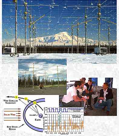
research experiment was conducted in cooperation with the NASA WIND
Satellite on November 16-17, 1996. The first comprehensive research campaign
was conducted during early March 1997.
The near term program goal is to provide a complete 48 element antenna
system including on-site power generation by fall 1998. Following the planned
upgrade, the facility should be capable of conducting high quality scientific
research by fall, 1998.
Both on- and off-site scientific, observational instruments are now
providing data on the natural high latitude ionosphere. Currently these
include a
magnetometer,
ELF/VLF receivers, an imaging
riometer, a 30
MHz riometer, a spectrum
monitor and a GPS based scintillation monitor.
Environmental Process
In accordance with the National Environmental Policy Act (NEPA), an environmental
impact statement (EIS) evaluated the consequences of constructing and operating
the HAARP research facility in Alaska. The EIS discusses impacts on such
diverse topics as electromagnetic and radio frequency interference, vegetation,
wetlands, wildlife, air quality, subsistence, cultural resources, atmosphere
and others.
State and federal environmental regulatory agencies were consulted to
identify issues, and additional input was solicited from the public during
scoping meetings held in Anchorage and Glennallen, Alaska in August 1992.
A draft of the EIS was prepared and distributed to the public and to specific
organizations on March 12, 1993. Public hearings were held in Glennallen
and Anderson, municipalities close to the sites under consideration. The
final EIS was released to the public on July 15, 1993 and the Record of
Decision selecting Gakona, Alaska as the site for the HAARP Ionospheric
Research Facility was signed on October 18, 1993.
In addition to the NEPA process described above, all applicable state
and federal regulations for construction and operation of the HAARP facility
are being complied with.
Additional Information
An updated version of this fact sheet will be issued as often as program
changes warrant to keep interested parties apprised of significant developments
in regard to HAARP. Any individual seeking additional information about
HAARP, or wishing to provide comments regarding HAARP, may contact:
-
Office of Public Affairs
Air Force Research Laboratory
3550 Aberdeen Ave S.E.
Kirtland AFB NM 87117-5776